Terrain Machine: Tan Mu's Landscape and the Algorithm of the Unbuilt City
In the city-building games that Tan Mu played as a child, construction began with a blank terrain. The player received an empty grid, a coordinate system of potential, and the first act of creation was to introduce topography: mountains raised by click and drag, river channels carved through the surface, elevation changes that would determine where people lived and how water moved. Only after the terrain was established did roads appear, following the logic of gradients and access, subdividing the surface into zones designated for residential, commercial, or industrial use. The player could zoom out to oversee traffic patterns and the emergent logic of urban flow, or zoom in to watch a fire spread through a neighborhood, a disaster simulated with the same technical fidelity as the transportation network. The city was a system before it was a place. Its citizens were data points and its neighborhoods were algorithmic outputs. And Tan Mu, looking at those simulated horizons on a screen in her childhood room in China, was being trained to understand cities as outputs of a process rather than as products of history.
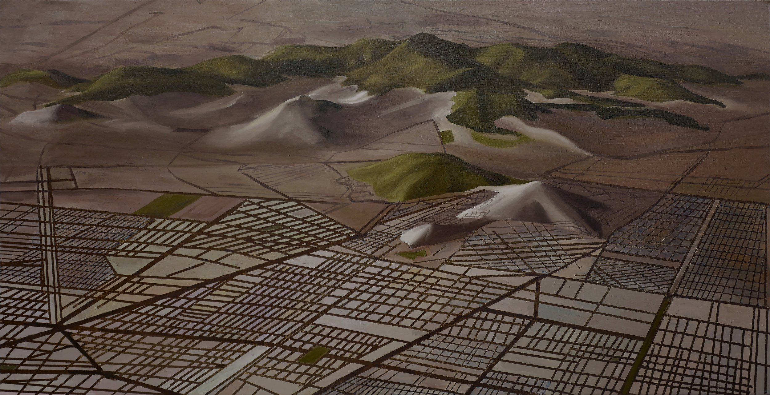
Landscape (2021) depicts the visual output of exactly this kind of digital terrain generation, and its subject is not the natural landscape that the title might suggest but the urban grid that the algorithm builds on top of the natural surface. The painting shows a virtual cityscape generated through 3D modeling software and then translated into oil paint on linen, its residential zones and transportation networks and industrial areas all present in the composition, their grid-like structure visible as a diagrammatic overlay on what would otherwise be a representational landscape. Tan Mu has described the grid in her painting as representing the neighborhoods and roads planned for a future city that may or may not ever be built in the physical world, and this conditional quality is central to the painting's meaning. The city in Landscape exists in the future tense. It is an urban plan, a digital blueprint that may be realized in concrete and steel or may remain forever as a simulation, a terrain that was designed but never inhabited.
The digital terrain models used in contemporary urban planning software are generated through a process called procedural generation, in which the large-scale features of the terrain are created by algorithms rather than by manual modeling. The algorithm takes as input a set of parameters specifying the desired characteristics of the terrain, such as average elevation, slope distribution, drainage patterns, and vegetation density, and then generates the full terrain automatically according to these specifications. This means that the terrain the painting depicts was not designed by a human being looking at a landscape and deciding how to represent it. It was generated by a function that took numerical parameters as input and produced spatial coordinates as output. The mountains and valleys and water channels are not observed. They are computed. Tan Mu has described being drawn to this computed quality of the digital terrain, the way it differs from the direct observation of natural landscapes that has historically motivated landscape painting. The digital terrain is a model, not a record, and the painting preserves this model-ness by translating it into the very different medium of oil paint, where every stroke is a manual decision that the algorithm never made.
Procedural terrain generation typically uses noise functions, most commonly Perlin noise or simplex noise, to create organic-looking elevation variation that would be prohibitively time-consuming to model manually. A single noise function call can generate elevation values for an entire terrain grid, with each point's height determined by the cumulative influence of surrounding noise octaves that control the large-scale smoothness and small-scale roughness of the result. The resulting terrain is technically infinite in resolution: any portion of it can be magnified and the noise function re-sampled to produce detail at the new scale, with no lower bound on the feature size that can be generated. This infinite resolvability is a fundamental property of procedural terrain that distinguishes it from photographed or hand-painted landscapes, which have a fixed resolution beyond which no further detail exists. Tan Mu's painting of this procedurally generated terrain has to make a decision about the scale at which to represent it, and the broad, atmospheric quality of the natural surface in the painting reflects the choice to represent the terrain at the scale where individual noise octaves become visible as regional features rather than at the microscopic scale where they would appear as texture detail.
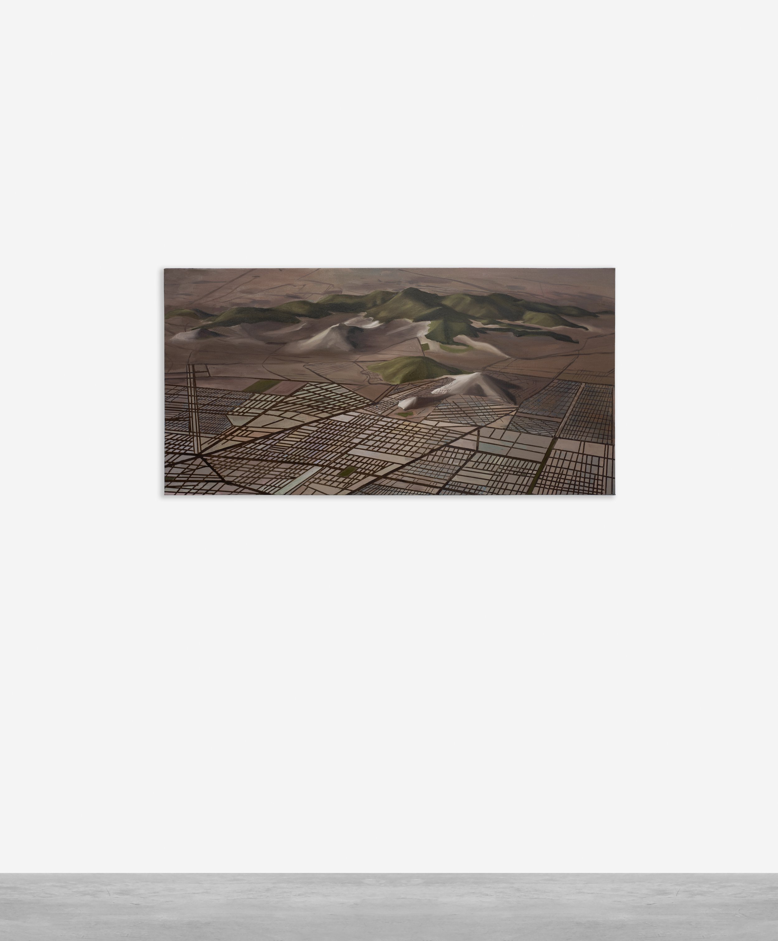
The painting measures 50.8 by 101.6 centimeters on linen, a horizontal format that corresponds to the wide-screen aspect ratio of the digital terrain viewer in the software that generated the original landscape. This format choice is significant. Tan Mu has framed the composition as a panorama, an expansively horizontal field that asks the viewer to scan laterally across the terrain rather than moving vertically through it. The horizontal orientation is the orientation of the bird's-eye view, the god's-eye perspective that the player occupies in the city-building game, looking down on the terrain from above as if from a reconnaissance aircraft. The viewer of the painting occupies the same position that the algorithm's user occupies when they design the city: suspended above the terrain, looking down, in control of the parameters of creation.
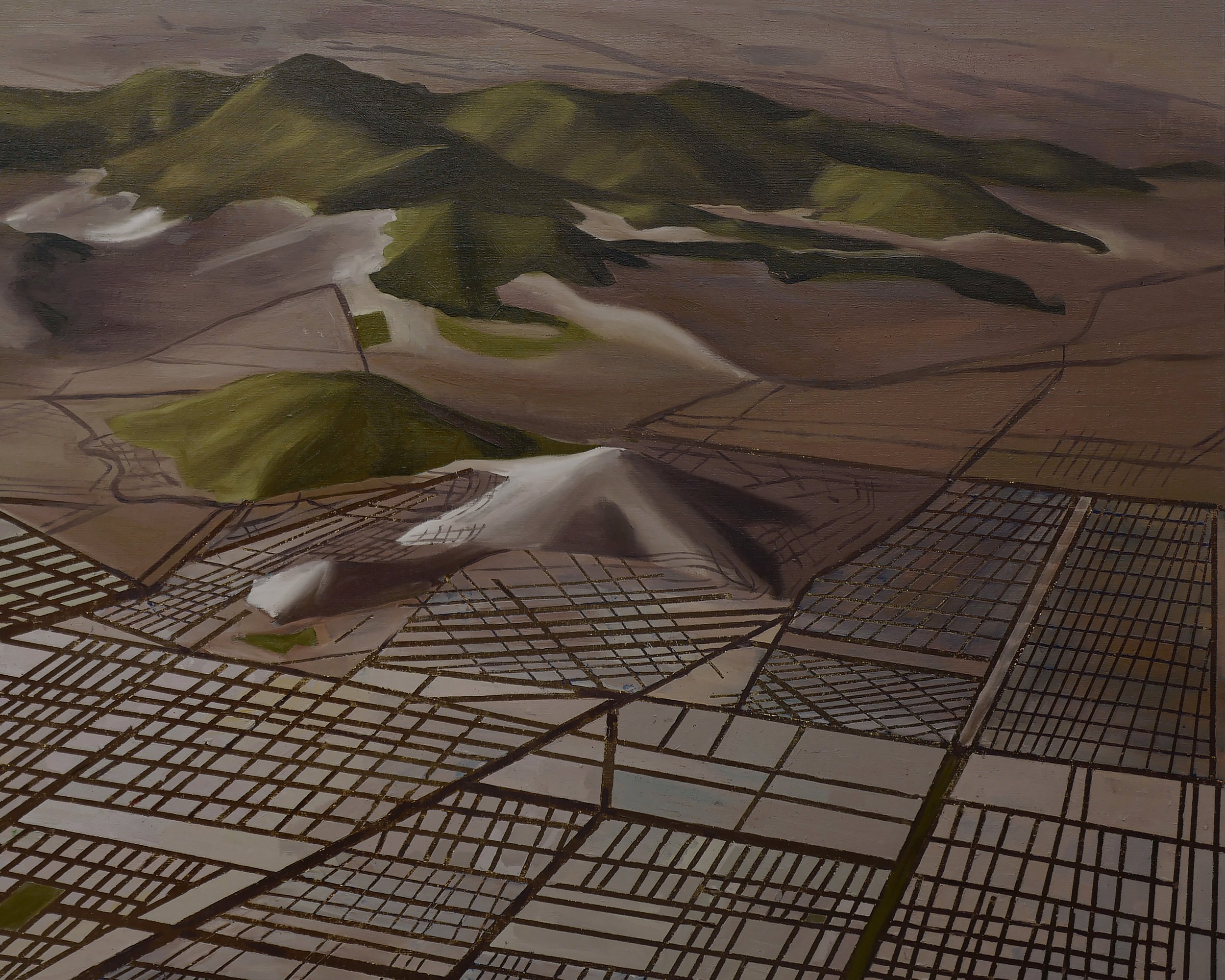
The paint handling in Landscape operates at two registers simultaneously, a duality that mirrors the painting's conceptual core. The natural terrain elements, the mountains and valleys and water channels that form the underlying surface of the digital city, are rendered in broad, atmospheric passages with a quality of soft edges and tonal gradation that recalls the Romantic landscape tradition, the painting of Caspar David Friedrich or John Constable as much as the output of a 3D modeling program. Against this atmospheric ground, the grid of the urban plan is painted with a contrasting precision: straight lines, sharp intersections, the hard geometry of residential blocks and arterial roads that impose a rational order on the softer natural surface beneath. The contrast between these two registers is the painting's central visual argument. The algorithm has covered the natural terrain with an artificial structure, and the painting makes both layers simultaneously visible, refusing to let either one disappear into the other.
Gerhard Richter began working with digital source material in the late 1980s, using digitized photographs and early computer manipulation techniques to generate paintings that occupied an unstable position between photographic documentation and painted interpretation. His series of works based on digitally sourced images in the 1990s demonstrated that the computer screen and the painted canvas were not opposites but complements, each capable of revealing things about visual information that the other could not. Richter painted images seen on screens, capturing the particular quality of resolution limitation, color compression, and pixelation that digital images carry within them as artifacts of their own production. His approach was never merely documentary. He was interested in what the digital image knew that the human eye could not see directly, the specific visual information that a scanned and processed photograph contained beyond its representational content.
Tan Mu's Landscape extends this investigation into the specific territory of urban planning software, asking what the digital terrain model knows about the city it is designing. In a 3D modeling program, the terrain is not merely represented. It is parameterized: every elevation change has a numerical value, every road has a defined width and surface type, every zone has a density specification, and the entire system is designed to be simulated, analyzed, and optimized before any physical construction begins. The grid that Tan Mu paints across her landscape is a visual output of this parametric system, a representation of decisions that were made in numerical form before any spatial form was assigned to them. Richter's digital paintings show the viewer what a photograph looks like after it has been processed by a machine. Tan Mu's Landscape shows the viewer what an urban plan looks like after it has been generated by an algorithm, translated from parameter space into painted surface.
The process of translating a digital terrain into oil paint is itself a form of what Tan Mu has described as the transformation between virtual and real, between rapid digital generation and handcrafted reproduction. The 3D modeling program can generate a complex urban terrain in minutes, placing thousands of buildings and kilometers of road network according to the parameters specified by the designer. The painting takes weeks. Each stroke of the brush is a manual act that cannot be undone or parameterized, a decision made in real time by a hand that cannot be duplicated by an algorithm. Tan Mu has described this slowness as integral to the work's meaning: the city that the algorithm generated in minutes is given, in paint, a durational presence that it would not otherwise have. The painting insists on the time that the digital process abolished, restoring to the urban plan the weight of physical making that the software specifically eliminates.
The grid structure in Landscape, which Tan Mu has explicitly identified as representing planned neighborhoods and roads for an unrealized future city, is not a random or arbitrary formal element. It is a structure that urban planners have used for thousands of years to organize human settlement, from the Roman centuriated grid to the orthogonal plans of Jefferson's city layouts to the zoning ordinances of contemporary municipalities. The grid is not merely a tool for organizing space. It is a statement about the relationship between human activity and territorial control, a way of saying: this land is divisible, assignable, and governable. When the algorithm generates a grid for a virtual terrain that may never be built, it is not merely producing a design output. It is reproducing the logic of territorial control that has organized human settlement since antiquity, and the continuity between the Roman centuriation and the algorithm's zoning specification is not metaphorical but structural. Both systems assume that land is a rationalizable resource and that the grid is the appropriate instrument for its rationalization.
The Roman practice of centuriation, developed during the Republic and Empire periods as a tool for the distribution of agricultural land to veteran soldiers and colonial settlers, created a systematic division of territory into square or rectangular units defined by a network of surveyed boundaries. The remains of these ancient land divisions are still visible in the landscape patterns of former Roman provinces, in aerial photography showing the persistence of orthogonal field boundaries across centuries of subsequent agricultural use. The grid was a technology of colonization: it announced that the territory had been claimed, measured, divided, and assigned, and that the original inhabitants' relationship to the land had been replaced by a new administrative order. Contemporary urban planning software performs the same function digitally, creating a grid of zones and corridors that expresses the same claim about the governability of territory, except that it operates on terrain that may never be physically occupied. The algorithm's grid is a colonization of the virtual, a claim staked in parameter space rather than on the ground, and the painting preserves this claim in a medium that will outlast the software that made it.
Andreas Gursky's large-format photographs of urban environments, from the眼花缭乱的 density of Tokyo to the algorithmic order of the Amazon fulfillment center, demonstrate that the contemporary city is fundamentally a system of flows, quantities, and optimization logics that the photographic image can represent but cannot fully resolve into human scale. Gursky's photographs are famous for their extreme resolution, their capacity to contain enormous amounts of visual information in a single field, and this resolution serves a specific conceptual purpose: it shows the viewer the city as data, as a set of patterns that can be read at multiple scales simultaneously but that resists any single scale of comprehension. His 1999 photograph Chicago Board of Trade shows the trading floor as a field of identical figures performing synchronized actions, each figure interchangeable with every other, the human content of the image reduced to a statistical density. His Tokyo photographs from the late 1990s show the city as a continuous fabric of construction and occupation, no empty space, no silence, the human presence overwhelming in its accumulation.
Tan Mu's Landscape takes from Gursky the interest in the city as a system of algorithmic organization rather than as a collection of individual buildings, but it applies this interest to the virtual city that has not yet been built rather than to the physical city that already exists. The grid in her painting is not a representation of a city that the viewer could visit. It is a representation of a plan for a city that exists only in parameter space, in the data structures of the modeling software. The terrain is still there beneath the grid, the mountains and valleys and water channels that the algorithm inherited from its natural source data, but the urban structure that will eventually cover that terrain is represented only as potential, as a set of zones and roads that might be built or might remain forever as pixels in a simulation. Gursky photographs cities that exist. Tan Mu paints cities that might exist, and this conditionality is not a limitation of the painting. It is its most precise observation about what urban planning has become in the age of digital design: a mode of producing futures that may or may not be realized, governed by logics that are legible in the plan but invisible in the lived city.
Sophie Steiner, writing in exhibition materials accompanying Tan Mu's recent exhibitions, has identified what she calls "the slowness argument" as central to Tan Mu's practice: the claim that the act of hand-painting a digital image introduces into that image a form of temporal weight that the digital image specifically refuses. Steiner connects this to a broader concern in Tan Mu's work with what might be called the afterlife of digital forms, the question of what happens to images, plans, and representations after they have served their initial purpose and passed into the category of the historical rather than the functional. The virtual cityscape that Tan Mu paints in Landscape was generated for a specific purpose that the painting does not identify and does not need to identify. It was a design output, a proposal for a development that may have been rejected, modified, or built under a different name in a different location. The painting preserves the design as an object of contemplation rather than a tool for construction, and in doing so it transforms the urban plan from a functional document into a meditation on what the digital city-building process reveals about the relationship between terrain and territory, between natural surface and administrative grid.
Tan Mu has described her childhood experience of city-building games as training her to think about cities as systems rather than as static images, and this systemic understanding is visible in every aspect of Landscape's composition. The grid does not represent individual buildings. It represents categories: residential, commercial, industrial, transportation. The terrain does not represent a specific landscape. It represents the generic conditions of terrain as such: elevation, drainage, gradient. Even the atmosphere of the painting, the soft tonal gradations and the broad, Romantic handling of the natural surface, represents not a specific natural landscape but the general idea of terrain as something that exists beneath and before human intervention. The painting is an essay on the logic of urban planning rather than a record of any particular plan, and this generality is what allows it to hold both the natural and the artificial in the same pictorial field without resolving them into each other.
The Mongolian trip that Tan Mu describes as the origin of her visual interest in vast, open landscapes is present in the painting not as a specific reference but as a formal condition. The scale of the terrain in Landscape is non-human, the kind of scale that the city-building game simulates when the player zooms out to oversee the whole system at once. This is not the scale of the walking figure in a landscape. It is the scale of the designer, the planner, the authority that looks down on the terrain from above and decides how it will be organized. Tan Mu occupies this position in the painting, aligning herself with the algorithmic eye rather than with the human scale, and the painting asks its viewers whether they are willing to occupy this position as well, to look at the city from above and to see in its grid not a neighborhood but a system, not a road but a flow, not a mountain but a parameter in a terrain model that some algorithm will eventually use to decide where people live and how they move.