The Empire That Went Underwater: Tan Mu's Signal 05 and the Routes That Never Disappeared
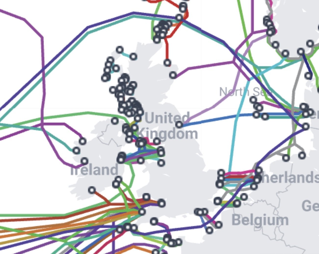
The first submarine telegraph cable connecting Britain to the European continent was laid across the English Channel in 1850, a single copper wire wrapped in gutta-percha, the latex of a Malaysian tree that happened to be the best electrical insulator available in the mid-nineteenth century. The cable failed on its first day. A French fisherman hauled it up in his nets, assumed it was a new kind of seaweed, and cut a section out to show his neighbors. The second cable, laid the following year with four copper cores and thicker insulation, worked, and for the next seventy years, until the development of radio telegraphy made copper wires at the bottom of the sea temporarily obsolete, the submarine cable network expanded outward from the British Isles in a pattern that replicated the routes of the Royal Navy and the merchant marine. The cable to Ireland came first, then the cable to France, then the cables to the Low Countries, Scandinavia, the Mediterranean, West Africa, India, Hong Kong, Australia, and New Zealand. By 1900, Britain owned and operated more than half of the world's submarine cables, and the network had become, in the words of a contemporary observer, "the nervous system of the empire." The routes that carried telegraph pulses in the nineteenth century are, in many cases, the same routes that carry fiber optic pulses today. The cables have been replaced, the bandwidth has multiplied by factors that would have been inconceivable to the Victorian engineers who laid the first copper cores, but the routes remain, because the routes were never chosen for technological reasons. They were chosen for geographic ones. The English Channel is narrow. The North Sea is shallow. The Irish Sea is short. The coasts of Scotland provide natural landing points facing the Atlantic. The same geography that made the British Isles a naval power made them a cable hub, and the same routes that carried tea, opium, cotton, and manufactured goods in the hold of a merchant vessel now carry financial transactions, cloud computing data, and internet traffic in pulses of laser light through glass fibers thinner than a human hair.
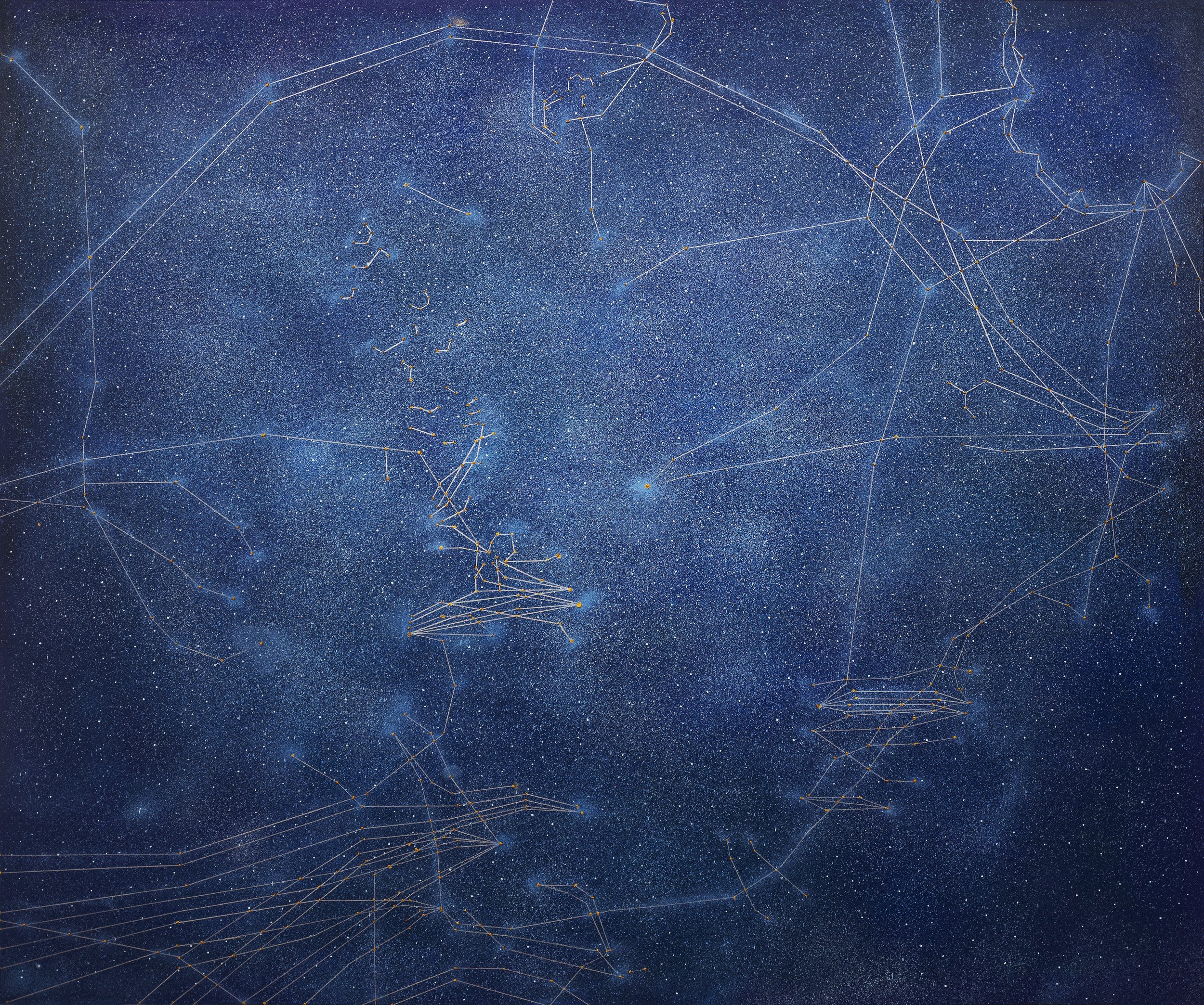
Signal: Submarine Network 05 (UK), 2025, is an oil and acrylic painting on linen measuring 152.5 x 183 cm (60 x 72 in). It depicts the submarine cable network surrounding the British Isles, tracing the web of cables that cross the North Sea, the English Channel, and the Irish Sea, with dense clusters of landings along the eastern coast of England and the western coast of Scotland. The composition is oriented with south approximately at the bottom, following the conventions of submarine cable maps, so that the British Isles occupy the center of the canvas as a recognizable landmass, with the English Channel at the bottom, the North Sea to the right, and the Atlantic approaches to the left. The land itself is not rendered as a detailed topographic image. It appears as a dark silhouette against the dark water, distinguishable from the surrounding ocean only by the concentration of bright nodes at the cable landing points along its coast. These nodes are the painting's brightest elements, clusters of white and pale gold pigment where multiple cables converge at a single shore station, and they mark the points where the underwater infrastructure touches the terrestrial backbone that routes data inland to London, Manchester, Edinburgh, and the data centers that have made the United Kingdom one of the largest markets for cloud computing in Europe.
The cable routes are rendered in acrylic over the oil ground, using a technique that distinguishes the permanent infrastructure from the ocean that carries it. The oil ground is laid in broad horizontal strokes that establish the dark marine tonality, a deep blue-black that reads as the North Sea and the Atlantic at depth, and it modulates subtly across the canvas, lighter in the shallow waters of the Channel and the southern North Sea, where the continental shelf keeps the water close to the surface, and darker in the deep water to the west of Scotland and Ireland, where the Atlantic drops off sharply toward the abyssal plain. This modulation is not merely atmospheric. It encodes bathymetric information: the cables that cross shallow water appear to lie near the surface, their lines bright and distinct against the lighter ground, while those that traverse deep water appear to plunge into the dark, their lines thinning and fading as the depth increases. The acrylic cables are applied in lines of varying thickness and brightness that follow the routes shown on submarine cable maps, and the variation is not arbitrary. The thickest, brightest lines correspond to the highest-capacity trunk cables that carry the most traffic, while the thinner, dimmer lines represent cables of lower capacity or cables that serve as redundancy rather than primary routes. The landing points, where the cables converge, are built up from multiple layers of acrylic applied in overlapping strokes, creating small mounds of pigment that sit slightly above the surface of the surrounding oil ground and catch the light when the viewer moves past the canvas, producing a subtle glint that replicates, at the scale of paint on linen, the way a shore station's lights would appear from a boat approaching the coast at night.
William Hodges was twenty-three years old when he joined Captain James Cook's second voyage to the Pacific in 1772, appointed as the expedition's official artist with instructions to record the landscapes, coastlines, and peoples encountered along the route. He spent three years at sea, painting harbors, bays, and headlands from the deck of HMS Resolution as it navigated the waters of the southern Atlantic, the Pacific, and the Antarctic. View of Pickersgill Harbour, Dusky Bay (1773, National Maritime Museum, Greenwich) is one of the paintings he produced during this voyage, and it shows a sheltered inlet on the coast of New Zealand, with dark water in the foreground, steep tree-covered slopes rising on either side, and a thin line of light where the sky meets the sea at the mouth of the bay. Hodges painted this view from the ship, looking inward toward the land, and the composition places the viewer on the water, looking at the coast as a sailor would see it, with the harbor as a point of arrival and the open sea as a point of departure. The painting is not a topographic record in the modern sense. It does not show the harbor with the precision of a survey chart. It shows it as a visual experience, the way the coast looked to a man who had been at sea for months and was seeing land for the first time in weeks, and the emotional register of the painting, its combination of relief at the sight of land and wariness at the strangeness of the landscape, is legible in the contrast between the dark, featureless water of the harbor and the intricate detail of the trees and rocks on the shore.
Hodges's harbor views and Tan Mu's cable maps share a logic of coastline as interface that is not immediately obvious because their visual languages and their moments in art history are so different. Hodges worked in oil on canvas at a scale suited to a gentleman's drawing room, and his audience was the British public who followed Cook's voyages through published accounts and exhibited paintings. Tan Mu works in oil and acrylic on linen at a scale that demands gallery wall space, and her audience is the international contemporary art world. But both artists take the coastline as a subject and render it as a zone of connection between land and sea, and both understand that the coastline is not a boundary but a membrane through which traffic passes in both directions. In Hodges, the traffic is physical: ships arrive, anchors are dropped, boats are lowered, sailors and officers go ashore, provisions are taken on board. In Tan Mu, the traffic is informational: data arrives, is routed through a landing station, is transmitted inland along the terrestrial backbone, and the process is invisible from the surface. The harbor that Hodges painted as a point of arrival for Cook's ships is, in many cases, the same harbor that serves as a landing point for submarine cables today. The sheltered bays and deepwater approaches that made a location suitable for a naval anchorage also make it suitable for a cable landing, because the same bathymetric features that protect a ship from the open sea also protect a cable from the chafing of waves and the drag of fishing gear. The routes that Cook followed across the Pacific were the same routes that the first submarine cables would follow a century later, because the routes were determined by geography, and geography does not change. The cable that lands at Porthcurno in Cornwall, one of the most important cable landing stations in the world, follows a route that was used by the packet ships carrying mail between Britain and India in the nineteenth century, and the packet ships followed the trade routes established by the East India Company in the seventeenth and eighteenth centuries, and those trade routes followed the monsoon winds and ocean currents that had guided Arab and Chinese merchants for centuries before any European ship entered the Indian Ocean. The routes accumulate. They do not disappear.
The submarine cable network depicted in Signal 05 is not a neutral infrastructure. It is an infrastructure shaped by history, and the history that shaped it is the history of British maritime power. The density of cable landings along the eastern coast of England, which the painting renders as a string of bright nodes running from Cornwall to Kent and up through East Anglia to the Humber and the Tyne, reflects the economic geography that developed over four centuries of maritime trade. The cable landing stations were built where they are because those were the locations where undersea cables could most easily reach the shore, and the cables were laid where they are because those were the routes that connected the British economy to its trading partners. The Channel crossing, the shortest sea route between Britain and the continent, carries the densest concentration of cables because it carries the most traffic, and it carries the most traffic because Britain and France have been each other's largest trading partners for centuries, a relationship that survived wars, revolutions, and the entire realignment of European politics because the Channel is only thirty-three kilometers wide at its narrowest point, and thirty-three kilometers of cable is cheaper to lay and easier to maintain than three hundred. The North Sea cables, which connect the eastern coast of England to the Netherlands, Germany, Denmark, and Norway, follow the same routes that the Hanseatic merchants followed in the medieval period and the same routes that the North Sea oil industry uses today, because the North Sea is shallow and its continental shelf provides a stable seafloor for cable installation. The cables that cross the Irish Sea, connecting Britain to the Republic of Ireland and to the submarine cables that run from Ireland westward across the Atlantic, follow the routes that the mail packets followed in the nineteenth century and the steam packets followed in the eighteenth, because the Irish Sea is narrow and sheltered and the approach to the Atlantic from the western coast of Ireland provides the shortest deep-water route to North America. None of this is visible in the painting as annotation. It is visible as density: the brightest clusters of nodes correspond to the most historically trafficked routes, and the pattern of brightness across the canvas is a map not just of cable infrastructure but of centuries of accumulated maritime commerce compressed into a single visual field.
Tan Mu's maternal great-grandfather was a maritime trader during the Republican era who navigated international waters between China and Korea, carrying goods across the Yellow Sea and the East China Sea on routes that, like the routes surrounding the British Isles, were determined by geography and sustained by trade. His ventures were disrupted by World War II, and he joined the overseas Chinese community in Korea before returning to China in later years. This transnational history, moving between nations by sea, is not incidental to the Signal series. It establishes a personal precedent for the understanding that the ocean is not a void between landmasses but a medium of connection, and that the routes that carry trade across water also carry culture, language, and memory. When Tan Mu paints the submarine cables surrounding the British Isles, she paints them with an understanding of what it means to cross water for a living, to follow routes determined by the depth of the sea and the direction of the wind, and to arrive at a foreign coast with goods or data to exchange. The great-grandfather's trading routes between China and Korea followed the Kuroshio current and the monsoon winds. The British cables follow the routes of the Royal Navy and the merchant marine. The vessels are different. The currents are different. The centuries are different. The logic is the same: water is the cheapest medium for moving anything between two coasts, and the cheapest route between two coasts is the one that has been traveled before.
Rachel Whiteread cast the interior of a Victorian terraced house in East London in concrete in 1993, filling the rooms, the staircases, and the hallways of 192 Grove Road with liquid concrete, removing the exterior walls after the concrete had set, and exhibiting the resulting sculpture on the site where the house had stood. House, as the work was titled, lasted eleven weeks before the local council demolished it in response to complaints from residents who found it ugly and disturbing. The sculpture was not a model of a house. It was the negative space of a house, the volumes that the walls had enclosed, made solid and permanent in a material that is normally used for foundations and load-bearing structures, not for domestic interiors. Whiteread's cast transformed the invisible into the visible by filling the voids that architecture creates and then removing the architecture, leaving only the space it had defined. The result was an object that looked like nothing anyone had seen before: a block of concrete with the imprint of a fireplace, the trace of a staircase, the ghost of a window, all the marks that a house leaves on the air inside it, made permanent in a material that would outlast the house itself.
Whiteread's House and Tan Mu's Signal 05 share a logic of making the invisible visible by inverting the relationship between structure and void. Whiteread fills the void and removes the structure. Tan Mu renders the structure and leaves the void dark. In House, the invisible is the interior space of a domestic building, which no one normally sees as a volume because it is the space you occupy, not the space you look at. In Signal 05, the invisible is the submarine cable network, which no one normally sees because it lies beneath the surface of the ocean and its presence is registered only in the data traffic it carries and the occasional maintenance ship that hovers above it. Whiteread's method is to fill the void with concrete, making the absence of the walls into a positive form. Tan Mu's method is to paint the cables as luminous lines against a dark ground, making the presence of the infrastructure into a visual composition that reads as both a technical map and a work of art. The two methods are opposite in their mechanics but identical in their effect: they make something visible that was previously invisible, and they do so by treating the invisible not as an absence but as a presence that requires a different kind of attention to perceive. Whiteread's concrete makes you see the air inside a house. Tan Mu's acrylic makes you see the cables under the sea. Both require you to look at something you normally look through, and both reward the attention with the discovery that the thing you were looking through has a structure, a history, and a logic that you had not noticed because it was too familiar or too hidden to register.
Yiren Shen, in her 2025 conversation with Tan Mu for 10 Magazine, observed that "when we talk about art and culture, it's all on the surface, on the land. We have different languages, music, arts, architectures, but it's always happening on the surface. Under the sea, it's a very uniform setting." The observation is precise and it extends to Signal 05 with particular force, because the painting depicts a region where the surface, the land above the waterline, is one of the most culturally dense and historically layered places on Earth. The British Isles have been inhabited, invaded, colonized, industrialized, and networked for millennia, and every square kilometer of the landscape carries the marks of that history. The sea floor beneath them, by contrast, is culturally uniform: a surface of sediment and rock, indistinguishable from the sea floor beneath any other coastline, bearing no marks of the civilizations above it except the cables they have laid across it. The painting renders this contrast in the simplest possible terms: the land is dark and the nodes are bright, while the sea is dark and the cables are bright. The same luminous logic governs both registers, because the same infrastructure connects them. The cable that lands at a node on the coast of Kent and the cable that crosses the Channel to France are the same cable, and the painting treats them as a single system that happens to pass through both environments, the cultural one above the water and the uniform one below it. Yiren Shen's observation that undersea culture is uniform is not a limitation. It is a condition. It is the condition that makes the cable network possible, because a culturally uniform sea floor is a sea floor that can be crossed without negotiation, without the permissions and accommodations that above-ground infrastructure requires, and the cables exploit this uniformity to connect the culturally dense places above the waterline with a directness that no terrestrial route can match. The sea does not have property lines. It does not have zoning regulations. It does not have heritage designations. It has cables, laid by ships, maintained by robots, and rendered visible by a painting that treats the underwater and the above-water as a single visual system governed by a single logic of luminous connection against dark ground.
The density of Signal 05, the concentration of bright nodes and bright lines in the narrow seas surrounding the British Isles, is the painting's visual argument that this region, more than almost any other on the planet, has accumulated so much maritime traffic over so many centuries that the routes themselves have become infrastructure. The Hanseatic League's trade routes through the North Sea became the Royal Navy's patrol routes, which became the telegraph companies' cable routes, which became the internet's fiber routes. Each generation laid its cables along the same seafloor, because the seafloor had already been surveyed, already been charted, already been proven stable. The routes accumulated like sediment, each layer building on the one below, and the painting renders this accumulation as brightness: the most trafficked routes are the brightest because they carry the most cables, and the most cables accumulate at the points where the routes converge, which are the natural harbors and sheltered bays that have served as ports for centuries. The painting does not narrate this history. It encodes it as luminosity, and the viewer who can read the brightness of the nodes and the thickness of the lines as a record of accumulated traffic is reading the painting as a compressed history of maritime commerce, naval power, telegraph engineering, and digital infrastructure, all of which followed the same routes across the same water, because the water was there and the routes were ready. The empire went underwater a long time ago. The routes it left behind are the routes we still use, and they carry everything we have, including the words you are reading now, which traveled, at some point in their journey from server to screen, through a fiber optic cable on the floor of the English Channel, following a route that was first surveyed by a ship in 1850.