The Routes That Stayed: Tan Mu's Signal: Submarine Network 06 and the Caribbean's Unbroken Circuit
In 1852, the first submarine telegraph cable was laid beneath the English Channel. Within three decades, colonial powers were stringing copper across the Caribbean, connecting Havana to Key West, Kingston to Panama, Barbados to Buenos Aires, so that the same sugar merchants who had financed the Middle Passage could confirm their shipments in minutes rather than months. The routes were not chosen for the convenience of the islands they passed. They were chosen for the extraction they served. When those copper telegraph lines decayed and were replaced, first by coaxial copper, then by fiber-optic glass, the replacement cables followed the same seabed grooves. The sea floor does not forget a trench. A cable laid in 1890 becomes a guide for a cable laid in 2025. The routes stayed. The cargo changed from molasses to megabytes, from dispatches to data packets, but the geography of connection remained the geometry of empire.
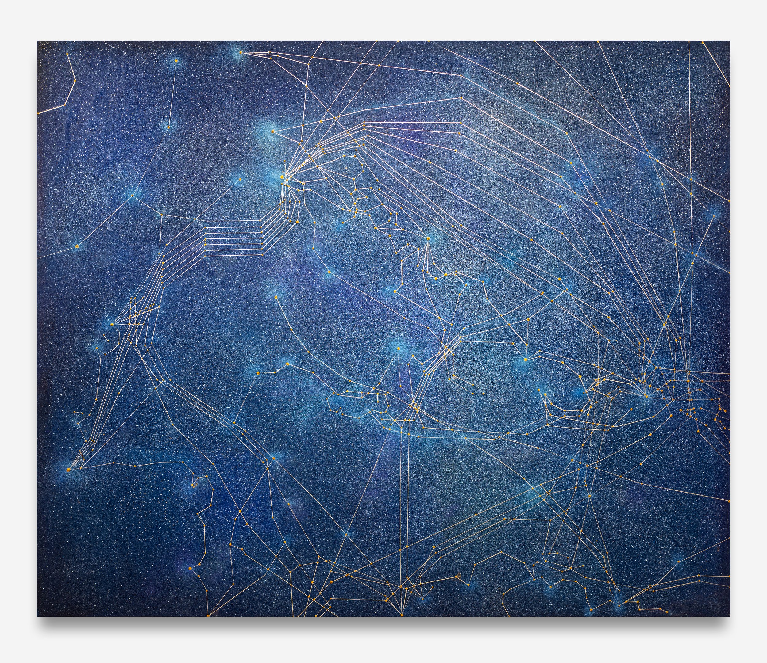
Tan Mu's Signal: Submarine Networks 06 (Caribbean Sea) (2025) makes this continuity visible. Oil and acrylic on linen, 152.5 x 183 cm, the painting maps the fiber-optic cable network threading through the Caribbean Sea, linking the Bahamas, Cuba, Jamaica, Haiti, the Dominican Republic, Puerto Rico, and the smaller islands that form the densest archipelago in the Western Hemisphere. The painting does not simply document infrastructure. It registers a historical fact that most cable maps omit: the Caribbean's digital connectivity is the latest iteration of a circuit that has been operating for five hundred years, first as a shipping lane for enslaved people and extracted commodities, then as a telegraph route for colonial administration, and now as a data corridor for global finance. The artist states it plainly on her artwork page: "Once a core maritime zone of colonial expansion and pirate lore, the Caribbean also bore witness to the transoceanic movement of sugar, rum, and spices, commodities deeply entangled with histories of violence and exploitation. Today, these submarine cables extend that legacy of 'connectivity' into the digital age, weaving once sea-separated islands into the global flow of information."

The surface of the painting announces its subject through accumulation. At three meters, the composition resolves into a dense web of luminous points connected by fine lines, spread across a dark ground that evokes the bathymetric depth of the Caribbean basin. The cable routes form recognizable geographic shapes: the long thin line of Cuba's northern coast, the cluster of landings around the Bahamas, the branching paths that converge on Puerto Rico and fan outward toward South America. At arm's length, the web disintegrates into individual decisions. Each landing station is a thick impasto node of wax-heavy oil paint, built up in layers so that it sits slightly proud of the linen surface. Tan Mu has described this technique in interviews: "The access points are built up with thick, wax-heavy oil paint, resembling the soldered connections of electronic circuits. Each connection point has a raised texture." The raised texture is not decorative. It is structural. A landing station is a place where a cable emerges from the sea floor and enters a facility on land. It is the point where the underwater becomes terrestrial, where the invisible becomes infrastructure. Tan Mu's paint enacts this transition: the flat, thinly painted cable lines of the deep sea give way to raised, tactile nodes at the shore. The surface topography of the painting maps the topography of the network itself.
The color carries its own argument. The underpainting, visible in the margins between cable lines, modulates between deep indigo and a warmer Prussian blue, establishing a chromatic field that reads as ocean but refuses to be merely oceanic. Over this ground, the cable lines are rendered in a pale ivory and muted gold, their thinness producing a visual vibration against the dark support. Where cable routes cluster around the major landing points, notably Havana, Kingston, and San Juan, the accumulated lines create pockets of luminosity that give the impression of city lights seen from space. This is not accidental. Tan Mu has said that from underwater, looking up, the ocean surface refracts light in a way that resembles the night sky, collapsing sea and cosmos into a single visual field. The painting holds both readings simultaneously: the Caribbean Sea from below and a star chart of digital constellations from above. The linen weave, visible in the unpainted margins, provides a subtle cartographic ground, its horizontal threads reading like latitude lines on a nautical chart.
What distinguishes Signal 06 from the other paintings in the Signal series is its density. The Caribbean is the most tightly cabled region per square kilometer in the Western Hemisphere. The same geography that made it a hub for colonial shipping, a chain of islands creating natural relay points between continents, now makes it one of the most concentrated zones of submarine cable infrastructure on Earth. Li Yizhuo, writing in the BEK Forum catalog, observes that Signal 06 is "flamboyant and unapologetically convoluted, reflecting the dense archipelago." The word "flamboyant" is precisely chosen. Where Signal 04 (Norway) conveys what Li calls "the orderliness and austerity of magnificent coastlines," Signal 06 spills across the canvas with a Baroque excess of connection. The cable routes do not form the clean radiating patterns seen in the Pacific paintings. They double back on themselves. They overlap. They create knots of intersection that are visually dense to the point of congestion. The painting's formal language mirrors the historical layering it depicts: too many routes, too many interests, too many centuries of traffic compressed into a single zone.
Wifredo Lam's The Jungle (1943) was painted in Havana by an artist who had returned to Cuba after years in Paris, where he had worked alongside Picasso and the Surrealists. Lam's painting presents a thicket of hybrid figures, part human, part vegetal, part animal, their bodies interpenetrating sugarcane stalks and smoke. The surface is dense to the point of suffocation. There is no foreground or background, no clear spatial hierarchy, only a tangle of forms that must be navigated the way one navigates a cane field: by pushing through, by accepting that the view ahead is always partially obscured. The painting's refusal of spatial clarity is its argument. The Caribbean that Lam depicts is not a picturesque tropical landscape of the kind marketed to tourists. It is a zone of forced convergence: African spiritual traditions, Catholic iconography, the visual language of European modernism, and the material fact of sugarcane, the crop that required enslaved labor and that shaped every aspect of the region's economy and culture. The density of The Jungle is not a stylistic preference. It is a historical condition. The Caribbean does not offer clean sightlines. It offers entanglement.
Tan Mu's Signal 06 arrives at a similar formal conclusion through a different medium and a different century. Where Lam rendered the entanglement of bodies, crops, and spirits, Tan Mu renders the entanglement of cables, data routes, and colonial trade routes. But the visual effect is related: a surface so dense with intersecting lines that the eye cannot settle on a single path. The painting refuses the clean, radiating constellation of Signal 04. Instead, it produces what Lam's painting produces: a field of congestion that registers, at the level of form, the difficulty of extracting a single narrative from a region where every route has been contested for five hundred years. The cable lines in Signal 06 do not simply connect islands. They overlap the routes of slave ships, the lines of sugar trade, the paths of Spanish galleons, the tracks of telegraph cables, and the corridors of cold war surveillance. Each new layer of infrastructure follows the grooves cut by the last. The painting's congestion is not a compositional failure. It is an archaeological accuracy.
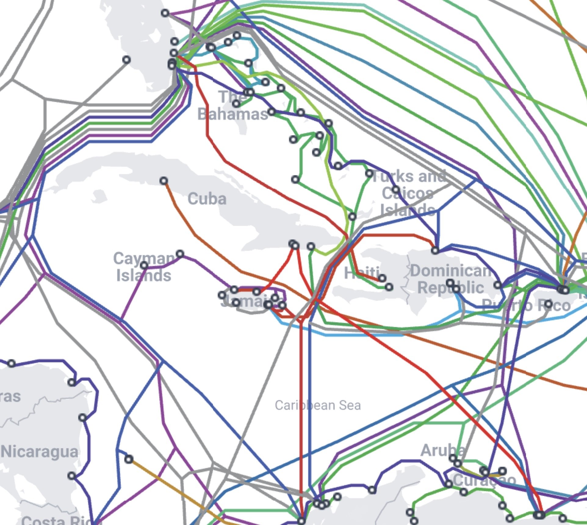
The Caribbean Sea is bounded to the north and east by the Greater Antilles, to the south by South America, and to the west by Central America. Within this roughly enclosed basin, submarine cables create a mesh of extraordinary density. According to TeleGeography's submarine cable map, the Caribbean hosts dozens of separate cable systems, including the East Caribbean Fiber System, the Americas-II cable, the Colombia-Florida Submarine Fiber Optic Cable, and the Gemini-Bermuda cable, among many others. These systems carry the financial transactions that make the Cayman Islands and the Bahamas major offshore banking centers. They carry the tourist bookings that sustain the economies of small island states. They carry the voice and data traffic that connects Caribbean diaspora communities in London, Toronto, and Miami to families in Kingston, Port-au-Prince, and Santo Domingo. The cables are not neutral infrastructure. They are the material substrate of a global economic order that has its roots in the plantation system and its branches in offshore finance. The same islands that were connected by the sea lanes of colonial commerce are now connected by the fiber-optic routes of digital capital. The cable map and the trade map overlap almost perfectly. The painting makes this overlap legible by presenting the cable network as a single visual field, without distinguishing between historical and contemporary routes, because in practice, the routes are the same.
The transition from colonial shipping to fiber-optic cable was not a clean break. The first submarine cable in the Caribbean was laid in the 1870s by the West India and Panama Telegraph Company, a British firm whose express purpose was to connect the colonial administration in Jamaica to the Colonial Office in London. The cable followed existing steamship routes. The steamship routes followed existing sailing routes. The sailing routes followed the currents and trade winds that had guided European ships since the sixteenth century. At each stage of technological upgrade, the existing route was the cheapest and most reliable guide for the new one. Sea floor topology reinforced this path dependence: the Caribbean basin has relatively shallow continental shelves around its island arc, making cable laying easier along the island chain than across the deep Yucatan Basin or the Cayman Trough. The geology of the sea floor, shaped by the same tectonic forces that created the islands, and the history of commerce, shaped by the same imperial forces that colonized them, produce the same path. Technology does not reroute. It overlays.
Kara Walker's A Subtlety, or the Marvelous Sugar Baby (2014) was a massive sphinx sculpted from sugar and installed in the Domino Sugar Refinery in Williamsburg, Brooklyn, shortly before the building's demolition. The figure, coated in bleached sugar and standing thirty-five feet tall, was a mammy-sphinx with exaggerated features drawn from racist iconography. Around her, Walker placed figures of sugar-coated children carrying baskets and bananas, their forms melting in the summer heat. The refinery itself was a monument to the sugar industry's economic power in New York, a city whose wealth was built, in significant part, on the processing of Caribbean cane sugar harvested by underpaid labor. Walker's installation made the building's architecture and the material of the sculpture conspire to produce a single argument: the refined sugar in the supermarket and the refinery on the waterfront and the sphinx in the warehouse are not separate phenomena. They are the same circuit, seen from different points. The sugar that built the sphinx came through the same ports that received the sugar that funded the factories that processed the sugar that sweetened the coffee that sat on the table while the refinery crumbled.
Walker's work registers what Tan Mu's painting registers: the persistence of routes across centuries of material change. The Caribbean shipping lanes that carried raw sugar to refineries in Brooklyn and Liverpool in the nineteenth century now carry fiber-optic data to data centers in Miami and London. The port of Kingston, Jamaica, which once received slave ships and dispatched sugar cargo, now hosts one of the most important submarine cable landing stations in the Western Hemisphere. The port of Havana, which once exported rum and molasses to Europe, sits at the convergence of multiple cable systems connecting the Caribbean to the Gulf of Mexico and the Atlantic. Walker's sphinx was made of the same commodity that traveled those sea lanes. Tan Mu's cable lines trace the same sea floor that received the ships. In both cases, the artist insists on continuity where the prevailing narrative prefers rupture. We like to believe that the colonial era ended, that slavery was abolished, that the Caribbean entered a postcolonial modernity. But the cables say otherwise. They say: the route from Kingston to London never closed. It was merely upgraded.
Tan Mu's own relationship to the ocean is neither academic nor abstract. She has dived in the Caribbean, at a site in Curacao where a submarine fiber-optic cable comes ashore beside a massive oil rig. In an interview with 10 Magazine, she described swimming beneath the rig's pillars: "We often think of these structures as artificial monstrosities, yet below the surface, they become marine habitats, like giant castles for sea life." The observation is characteristic. Where most commentators see the oil rig as an intrusion, Tan Mu sees a habitat. Where most see the cable as infrastructure, she sees an extension of the body. She has described submarine cables as "the veins of the planet, similar to meridian lines in traditional medicine, circulating energy and information through a living body." This is not a decorative metaphor. It is a structural claim. If the cables are veins, then the Caribbean is not a network node. It is a circulatory bottleneck, a place where the planet's circulatory system narrows and concentrates, where the volume of flow is highest and the consequences of blockage are most severe.
The 2022 eruption of Hunga Tonga-Hunga Ha'apai demonstrated this vulnerability in real time. When the volcanic blast severed the single submarine cable connecting Tonga to the global internet, the nation went dark for five weeks. No phone calls, no banking, no emergency coordination. A country of 106,000 people was cut off from the world because one cable broke. Tan Mu painted Eruption that same year, marking the moment of reconnection when the cable was repaired. The experience catalyzed the entire Signal series, transforming her attention from a single event to the infrastructure itself. If a single cable failure could isolate an entire nation, then the density of Caribbean cabling is not redundancy. It is a map of dependence. Every cable that threads through the Caribbean is a lifeline for the island it serves. Every cable is also a point of potential rupture. The density that Li Yizhuo calls "flamboyant and unapologetically convoluted" is, in material terms, a measure of how much the global economy depends on routes that pass through a sea floor no one can see.
The artist's description of the Caribbean as a zone where "connectivity" extends a legacy of colonial extraction into the digital age is framed by quotation marks around the word itself. The scare quotes are deliberate. "Connectivity" is the euphemism of the digital age, the way "civilization" was the euphemism of the colonial one. To connect is assumed to be good. To extend connectivity is assumed to be progress. But the Caribbean's history of connectivity includes the Middle Passage, the sugar trade, the rum trade, the arms trade, and every other form of traffic that moved through these waters under the flag of empire. The word "connectivity" cannot be used innocently in the Caribbean. Every connection has a cost. Every route has a history. The painting holds this tension in its formal structure: the cable lines are beautiful, luminous, precisely rendered, and they trace paths that were first cut by ships carrying human cargo. The beauty of the network and the violence of its origins coexist on the same surface, separated by a century of technological progress but not by a meter of sea floor.
Tan Mu has invoked The Classic of Mountains and Seas (Shan Hai Jing), the ancient Chinese text that maps mythical geographies and unknown territories, as a framework for the Signal series. The comparison is apt but incomplete. The Classic of Mountains and Seas charted what its authors believed to be real places, populated by real creatures, even if those creatures and places stretched the limits of empirical verification. It was a cosmographic text, an attempt to map the entire known and unknown world in a single system of description. The Signal paintings perform a similar function for the digital age. They map the hidden geography of global communication, a geography that exists, that is empirically verifiable, but that most people never see. The submarine cable map is a Shan Hai Jing for fiber optics: a chart of a world that is as invisible to daily experience as the mythic mountains were to the ancient Chinese reader. The difference is that the cables are not mythic. They are real, they are load-bearing, and they are concentrated, in the Caribbean, with a density that reveals as much about the region's colonial past as about its digital present.
The painting's title specifies "Caribbean Sea," not "West Indies" or "Greater Antilles." The choice is significant. "West Indies" is a colonial name, imposed by a navigator who thought he had reached the eastern coast of Asia. "Greater Antilles" is a geographic classification that isolates the large islands from the smaller ones. "Caribbean Sea" names the body of water itself, the medium through which all these routes pass, the substrate that makes every connection possible. The painting is not about Cuba or Jamaica or Puerto Rico as individual entities. It is about the sea that connects them and the cables that formalize that connection. The sea is the common condition. The cables are the variable. But as the painting demonstrates, the cables follow the sea's contours so precisely that they become legible as sea floor cartography. The cable map and the bathymetric map are, in the Caribbean, nearly identical. The infrastructure has adapted itself to the geography with a fidelity that suggests not engineering efficiency alone but geological determinism. The sea floor was shaped by tectonics. The routes were shaped by empire. The cables were shaped by both.
At 152.5 x 183 cm, the painting is large enough to enter physically. Standing before it, the viewer occupies the position of a satellite looking down at the Caribbean basin, or, equivalently, the position of a diver looking up from the sea floor. The scale is neither overwhelming nor intimate. It is cartographic. The painting is the size of a nautical chart, and it functions like one: a surface that condenses a vast geography into a readable field. The difference is that a nautical chart abstracts away the sea floor in favor of coastlines and depth soundings. Tan Mu's painting abstracts away the land in favor of the cables. The islands appear only as clusters of landing stations. The coastlines are traced not by paint but by the absence of cable lines. The painting maps not the Caribbean's surface but its infrastructure, and in doing so, it maps the forces that have shaped that infrastructure over five centuries of extraction, connection, and dependence.
The Caribbean's cable density is a function of its geography and its history. It is also a function of its political economy. Small island states lack the bargaining power of large continental nations. They cannot demand that cables follow routes that prioritize their development. Cables follow routes that prioritize the interests of the corporations and governments that fund them. In the Caribbean, this means that cable routes cluster around financial centers, the Cayman Islands, the Bahamas, Bermuda, rather than around population centers, Haiti, the Dominican Republic, Jamaica. The cable map of the Caribbean is not a map of where people live. It is a map of where money moves. The painting does not label this distinction, but it makes it visible. The clusters of landing stations in the northern Caribbean, where the offshore banking centers sit, are denser and more luminous than the sparser connections in the southern Caribbean, where the poorer islands are. The painting's light distribution maps the distribution of capital. The brightest points on the canvas are the points where the most money passes through the sea floor.
The Signal series is, among other things, an atlas. Each painting maps a different region of the global submarine cable network, building toward a comprehensive chart of the planet's hidden digital geography. Signal 06 is the Caribbean page of this atlas, and it is the page where the atlas's method reveals its deepest implications. In the Northwest Pacific, where the series began, the cables follow trade routes shaped by contemporary commerce. In Norway, they follow the austere contours of the North Sea's fishing and energy economy. In the Caribbean, they follow the routes of empire. The same method, applied to different regions, produces different histories. The atlas does not argue. It reveals. And what it reveals in the Caribbean is that the digital age did not arrive on clean wires. It arrived on wires laid in trenches cut by ships that carried sugar and human beings, and the trenches are still there, and the cables are still there, and the routes that stayed are the routes that bound the Caribbean to the world's centers of power five hundred years ago and bind it still.
The painting's final resonance is not in the cables themselves but in the space between them. The dark ground of the Caribbean Sea, rendered in indigo and Prussian blue, occupies more of the canvas than the cable lines. This is the medium through which everything passes: the slave ships, the sugar cargo, the telegraph pulses, the data packets, and, in Tan Mu's experience, the freediver's body, suspended at neutral buoyancy, watching the light refract through the surface above. The cables are the visible infrastructure. The sea is the invisible condition that makes the infrastructure possible. The painting holds both in a single field, the luminous routes and the dark water, and refuses to privilege one over the other. The sea was there before the cables. The cables were laid through the sea. The sea will outlast the cables. But for now, for the historical moment this painting documents, the two are inseparable. The Caribbean Sea is not a container for cables. It is a medium that has been shaped, over centuries, by the routes that pass through it, and those routes, from the first Spanish caravel to the last fiber-optic repeater, have always led the same direction: outward, toward the centers of empire, and inward, toward the extraction of everything the islands contain. The cable map is the latest page of a route book that has been in continuous use for five hundred years. The paint makes it legible. The sea makes it possible. The history makes it inescapable.