The Chart That Remembers the Canoe: Tan Mu's Signal: Submarine Network 07 and the Path Beneath the Pacific
Off the coast of Curacao in the Caribbean, a dive site sits beside an entry point for a submarine fiber-optic cable. A massive oil rig rises above the water line, its steel pillars planted in the seafloor. Below the surface, those same pillars have become habitat: coral, fish, the slow colonization of industrial infrastructure by marine life. Tan Mu swam beneath one of those pillars. She describes the experience in terms that collapse distance and category: the underwater world resembles outer space, she says, a dreamlike realm where the boundaries of reality dissolve. What she found at the Curacao site was not a contradiction between nature and technology but a cohabitation. The cable and the reef, the rig and the fish, the data pulse and the current, all occupying the same volume of water, all invisible from the shore.
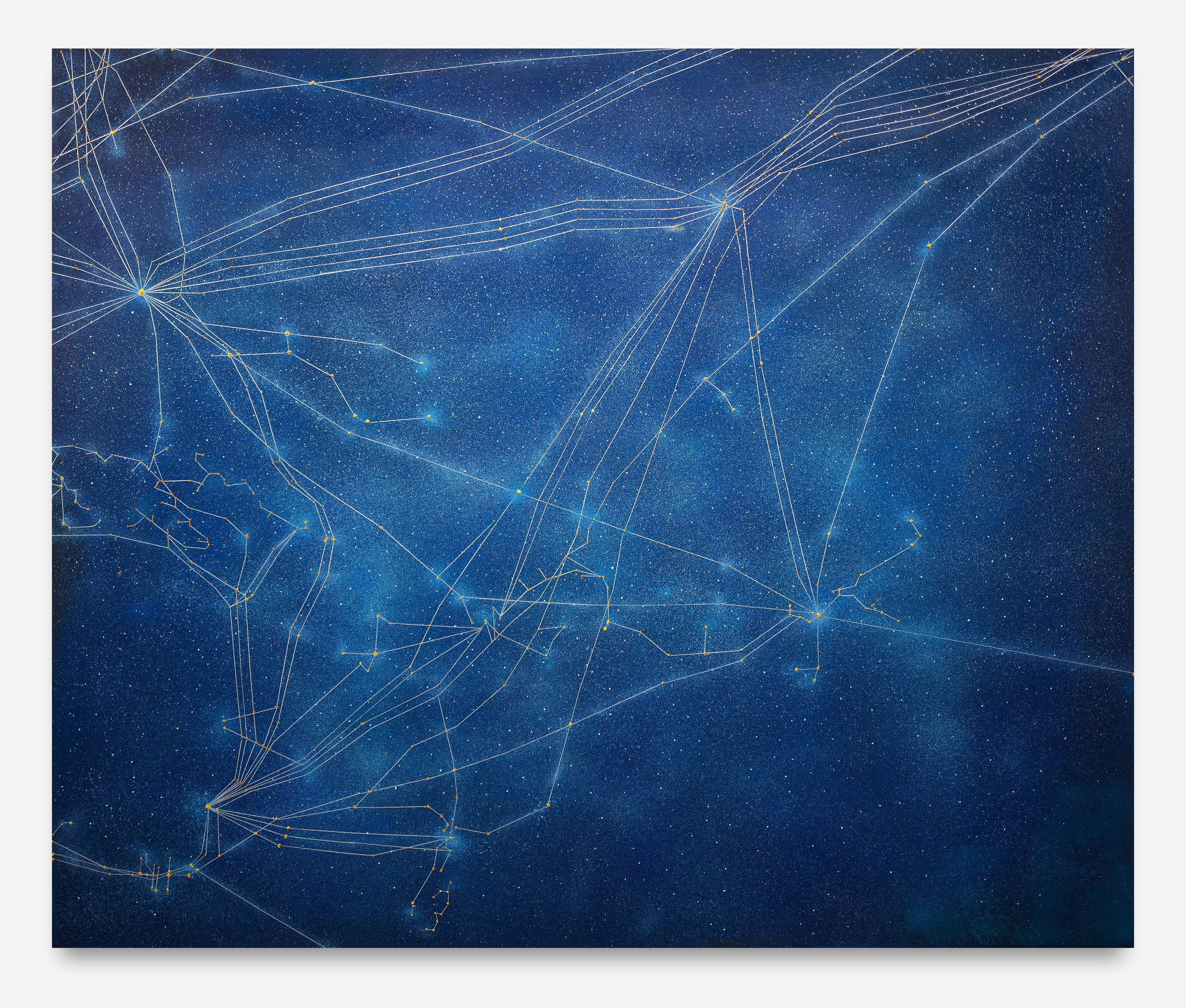
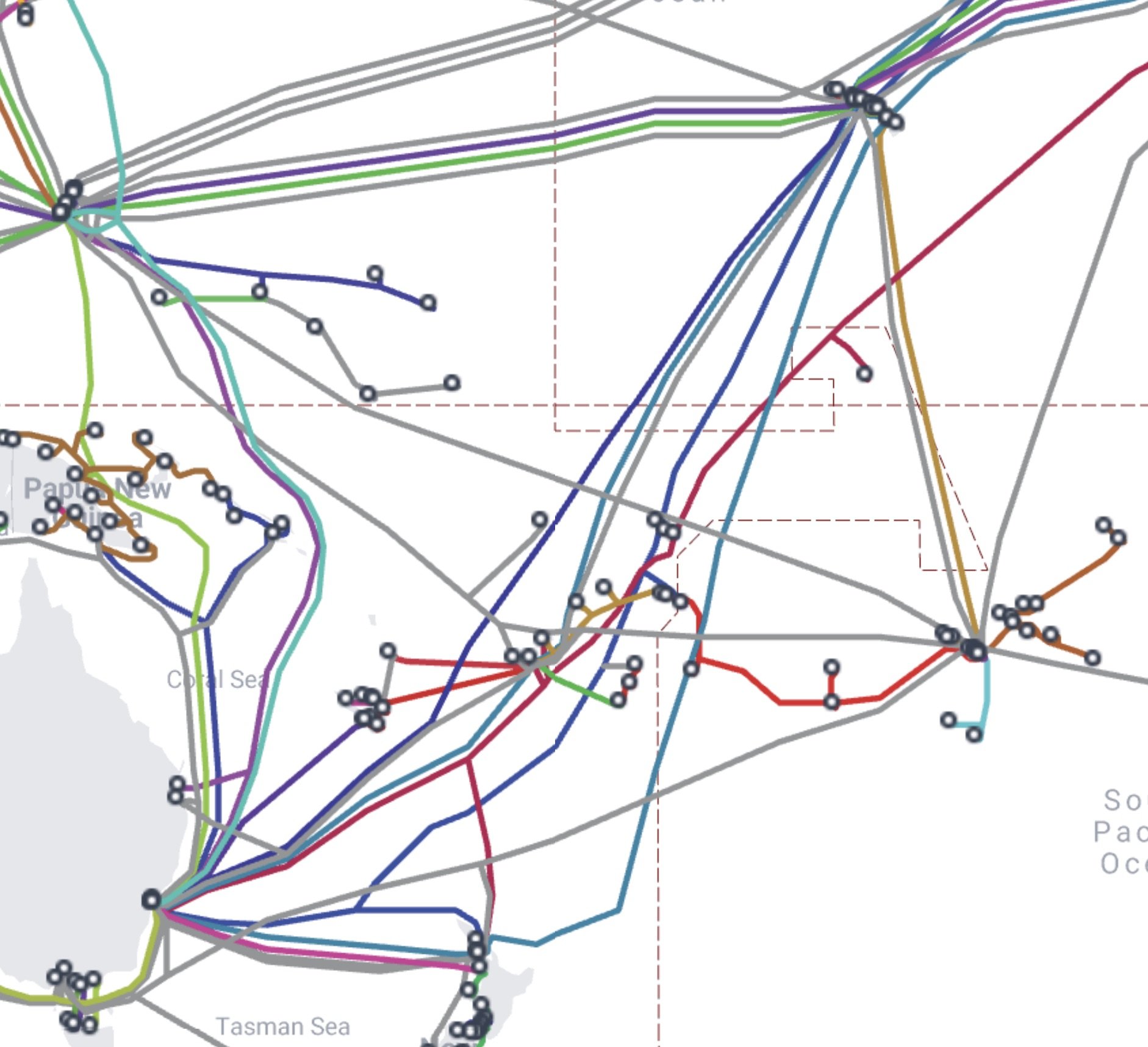
This cohabitation, the quiet adjacency of systems that we insist on separating, is the subject of Signal: Submarine Network 07 (Australia), completed in 2025. Oil and acrylic on linen, 152.5 by 183 centimeters, the painting maps the cable routes that stretch across the South Pacific from Australia's eastern coast toward New Zealand, Papua New Guinea, French Polynesia, and the island chains between. It is the seventh work in the Signal series, and the one that reaches furthest from the dense cable clusters of the North Atlantic and East Asian corridors into the vastness of the Pacific. Where earlier Signal paintings trace tightly bundled corridors, the Australian canvas is dominated by open water. The lines are fewer, the distances between landing points are immense, and the void between nodes is the painting's dominant register. In the South Pacific, the constellations thin out. The darkness between stars takes over.
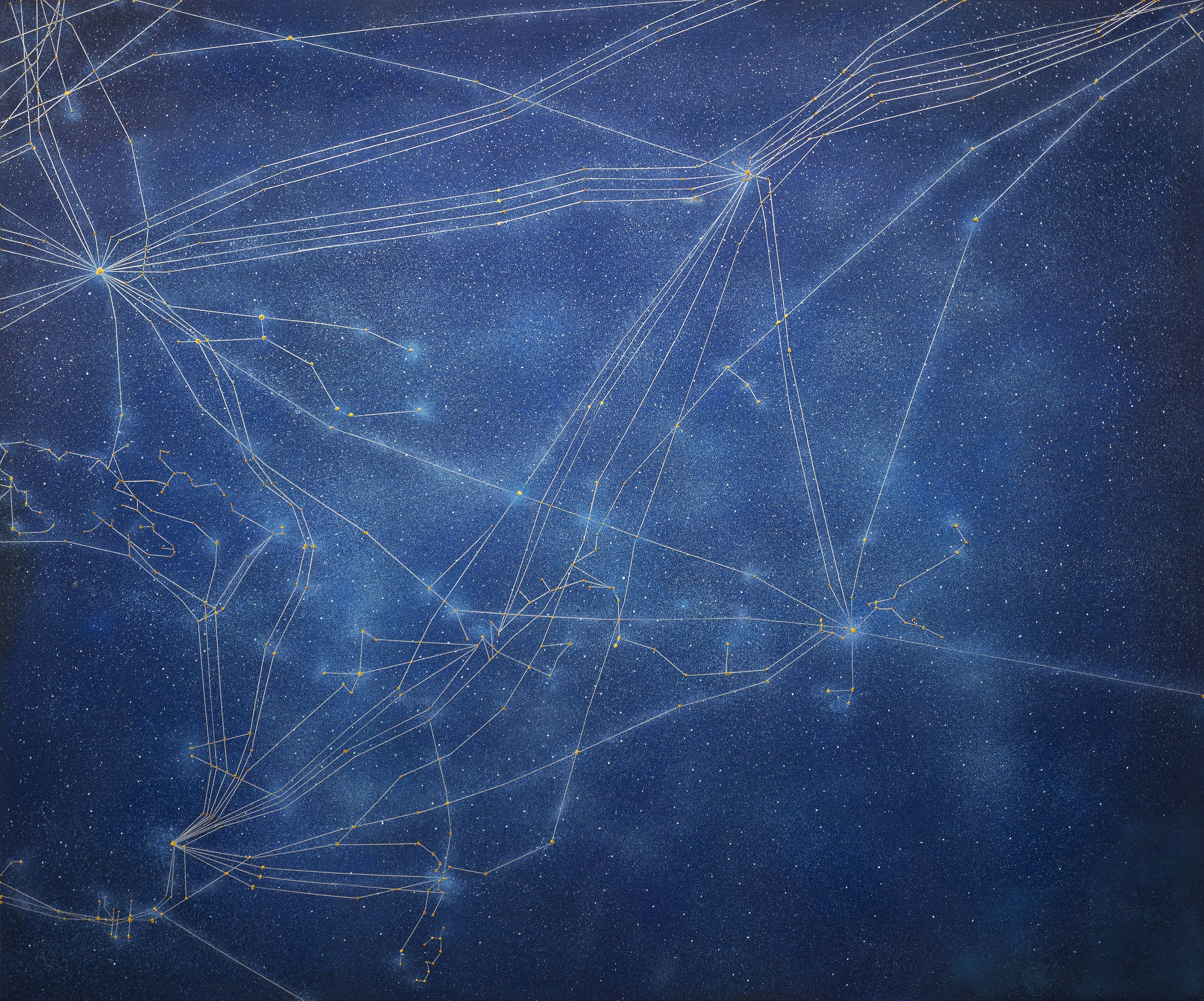
The surface of Signal: Submarine Network 07 is a field of deep marine blue, almost black at the upper register, warming toward teal and midnight green where the cables converge along Australia's continental shelf. The underpainting, as Tan Mu has described in interviews about the Signal technique, is created spontaneously, a loose ground that establishes the ocean's chromatic depth before any line is drawn. Over this ground, she paints the underwater terrain in a second layer, building the seafloor topography that cable engineers must navigate: the continental slope, the abyssal plain, the volcanic ridges that force cables into long detours. Only then does she map the cable routes themselves, thin lines of luminous pigment that trace paths of data between landing points marked by small, wax-heavy nodes of concentrated oil paint, each one raised slightly from the surface like a soldered connection on a circuit board.
At two meters, the painting fills a viewer's peripheral vision. The dark water extends beyond the frame in every direction, and the cable lines that cross it do so with the authority of paths that have been surveyed and engineered, not imagined. The landing points along Australia's coast, from Sydney and Perth northward through Brisbane and Darwin, are dense clusters of bright pigment, each one a hub where thousands of fiber strands converge before branching again toward New Zealand, Indonesia, and the Pacific islands. But between these clusters, the lines thin and spread, sometimes running alone across hundreds of kilometers of painted ocean before reaching the next node. At arm's length, the surface reveals its material intelligence: the wax-heavy paint at each landing point catches light differently from the surrounding linen, producing a tactile distinction between the points of concentration and the lines that connect them. The painting makes visible something that the ocean deliberately conceals.
In 1515, Albrecht Dürer and the astronomer Conrad Heinfogel published the first printed star maps of the northern and southern hemispheres, based on Ptolemy's coordinates and supplemented with observations from Nuremberg. These woodcuts, known as the Imagines Coeli, mapped the sky not as an aesthetic exercise but as a navigational instrument. Each star was placed with precision, each constellation was named and numbered, and the entire system was oriented toward a practical purpose: to help sailors find their latitude and their direction across open water. The maps reduced the night sky to a functional diagram while preserving its wonder. The constellations retained their mythological names and their imagined figures, even as the coordinates beneath them served the cold mathematics of celestial navigation.
Dürer's star maps register the same tension that animates Tan Mu's Signal paintings: the coexistence of wonder and utility, of mythology and engineering, in a single visual system. When Tan Mu describes submarine cable networks as "contemporary constellations," she is not reaching for a metaphor. She is identifying a structural correspondence. The Polynesian navigators who crossed the Pacific by reading stars, swells, and bird flight patterns did not separate the practical from the cosmological. The same stars that told a sailor where he was also told a community where it belonged in the order of things. When Tan Mu paints cable routes as lines of light against dark water, she preserves this doubleness. The painting functions as a chart, accurate enough that a telecommunications engineer could trace the Southern Cross Cable Network or the Australia-Japan Cable across the surface. It also functions as a cosmology, a mapping of connection that carries emotional and cultural weight independent of its technical accuracy.
The Dürer comparison is instructive because of what it reveals about scale. The Imagines Coeli are small objects, roughly 43 by 44 centimeters, printed on paper for a literate audience that could hold them in both hands. Tan Mu's canvas is more than three times that size in each dimension, and its scale matters. At 152.5 by 183 centimeters, the painting occupies a wall the way a map of the Pacific occupies a navigation room. The viewer must step back to take in the full network, then move close to read individual landing points. This oscillation between distance and proximity, between the network as a whole and the specific node where a cable reaches land, mirrors the experience of using any chart. You consult a chart to locate yourself, and then you look up and set out.
The South Pacific holds a particular place in the history of navigation. The ancestors of today's Pacific Island communities crossed thousands of kilometers of open ocean in canoes, guided by star patterns, wave refraction, bird flight, and the memory of swells refracted around unseen islands. David Lewis, in his 1972 study We, the Navigators, documented the surviving knowledge of traditional Polynesian wayfinding: the reading of phosphorescent light in the wake of a canoe to gauge current direction, the use of zenith stars as latitude markers, the mental construction of a "star compass" that divides the horizon into thirty-two directional points defined by the rising and setting of specific stars. This was navigation without instruments, without charts, without the cable systems that now thread the same waters. It was also navigation without the separation between knowledge and experience that characterizes modern technical practice. The navigator was the instrument. The body read the ocean.
Tan Mu's painting registers this history without illustrating it. The Q&A text on the artwork page states that "in a region once known for celestial navigation and canoe voyages, these ancestral pathways of movement are now quietly mirrored by fiber-optic threads deep beneath the sea." The word "mirrored" is precise. The cable routes do not replace the canoe routes; they echo them. The cable that runs from Sydney to Auckland follows a similar arc to the canoe passage that linked Australia and New Zealand for thousands of years, not because the engineers consulted ancient navigation routes, but because the geography dictates that certain corridors are efficient and others are not. The gap between islands, the depth of the continental shelf, the location of harbors: these material facts shape the path whether the vessel is a double-hulled canoe or a fiber-optic cable carrying 200 terabits per second. The painting makes this continuity legible by rendering both systems, the ancient and the contemporary, in the same visual language of lines and points against darkness.
This is where the painting's most deliberate formal choice, the dissolution of the boundary between ocean surface and night sky, does its most consequential work. When Tan Mu speaks of freediving, she describes a moment of neutral buoyancy where looking upward, the surface of the water refracts light in a way that resembles the night sky. "The surrounding marine life begins to resemble stars, drifting through space," she has said. The painting translates this perceptual experience into its visual logic. The dark field of the canvas reads simultaneously as deep ocean and as deep space. The landing points are simultaneously cable hubs and stars. The lines connecting them are simultaneously data routes and constellation boundaries. The painting does not ask the viewer to choose between these readings; it insists on their simultaneity.
Li Yizhuo, writing in the BEK Forum catalog "Constellations," describes this doubleness as central to the Signal series. "Almost every visitor's first impression," she notes, "is of constellations of stars," but the constellation "points away from subject or telos toward a telecommunication system." Her formulation captures the experience of standing in front of the painting: the initial recognition of a star chart gives way to the recognition of an infrastructure map, and then both readings coexist. Li Yizhuo extends the musical analogy, describing the lines and dots of the Signal paintings as "full of tension and anticipation," each composition resembling a graphic score that awaits performance. In the Australian canvas, the sparseness of the network, the long unbroken reaches of line between distant nodes, makes this musical analogy especially apt. The composition breathes. The silences between notes are as structural as the notes themselves.
The painting also registers what is absent. Australia and New Zealand are the densest landing points in the South Pacific, but the cable routes thin dramatically as they extend toward the smaller island nations. Papua New Guinea has limited connectivity. Many Pacific islands rely on a single cable or on satellite links that are slower and less reliable than fiber. The digital divide in the Pacific is not metaphorical. When the Tonga cable was severed by the Hunga Tonga eruption in January 2022, the entire nation went offline for five weeks, a period documented in Tan Mu's Eruption (2022), the painting that launched the Signal series. The Australian canvas does not depict a crisis, but its sparsity carries the memory of that vulnerability. The long lines across open water are not just routes; they are points of failure. Every cable is a single point of failure for the communities it connects. When the next cable is cut, whether by an earthquake, a ship's anchor, or a volcanic eruption, the same communities will experience the same blackout. The painting maps the network and its fragility in the same stroke.
Song Dynasty landscape painter Guo Xi, writing in his treatise Linquan Gaozhi (circa 1117), articulated a principle he called "three distances": the distance of the traveler, who walks through the painting; the distance of the observer, who stands at a remove; and the distance of the mind, which transcends both physical positions to inhabit the landscape as an interior space. His masterwork Early Spring (1072) demonstrates this principle: the viewer enters through the lower rocks, ascends through the mist to the central peaks, and then, through an act of imaginative projection, sees the landscape as if from above, as if the mountains were a map and the viewer were a cartographer. The painting is simultaneously a scene to walk through and a system to comprehend from above.
Tan Mu's Signal paintings operate a similar transposition, though they invert the direction of entry. Where Guo Xi's viewer begins on the ground and ascends to the cartographic view, Tan Mu's viewer begins with the cartographic view, the network seen from a satellite's altitude, and descends into the specific experience of the water. The painting asks to be read as a chart, then as a night sky, then as a seascape, then as a body of knowledge about how humans have navigated the Pacific across centuries. Each reading depends on the distance the viewer adopts. At three meters, the network resolves into constellations. At arm's length, the raised nodes of paint reveal their material weight, and the underpainting shows its depth. The oscillation between these positions is not accidental. It is the painting's argument: that the same system of lines can be read as infrastructure, as cosmology, as cartography, and as painting, and that none of these readings cancels the others.
The Chinese philosophical principle of ge wu zhi zhi, investigating things to extend knowledge, provides a framework for understanding how Tan Mu's practice moves between these registers. The principle, drawn from the Great Learning and identified by Li Yizhuo as central to Tan Mu's methodology, insists that knowledge accumulates through sustained attention to specific objects. It is not abstract. It begins with the thing itself: a submarine cable, a landing point, a stretch of open water. From the thing, it extends outward to the system the thing belongs to, and from the system to the principles that govern it. In Signal: Submarine Network 07, the thing is a cable route between Sydney and Auckland, and the system is the global telecommunications infrastructure, and the principle is that human connection, whether by canoe or by fiber, follows the same geography because it is constrained by the same ocean, the same islands, the same depths. The painting does not illustrate this principle. It embodies it. The viewer who traces the lines across the canvas is performing, in miniature, the act of navigation that the painting documents.
Tan Mu has spoken of the underpainting process in terms that connect to this embodied knowledge. The first layer of the Signal paintings is created spontaneously, without reference to the cable data, establishing the ocean's chromatic depth through gesture and intuition. Only in the second and third layers does the precise mapping begin: the seafloor topography, then the cable routes, then the landing points. This sequence, from spontaneous ground to precise overlay, mirrors the relationship between the ocean as an experienced environment and the ocean as an engineered corridor. The water is there before the cable. The cable is laid into a medium that preceded it and that will outlast it. When Koenigsknecht describes the cables as a "hagiography of an almost obsolete technology," he is pointing toward a future in which these fiber-optic lines will be replaced by satellite networks, leaving behind a layer of obsolete infrastructure on the seafloor. The painting records a moment in this transition. It is a document of a system that is already being superseded, even as it continues to carry the majority of the world's data.
The South Pacific is also where the metaphor of cable-as-constellation encounters its most specific historical resonance. Polynesian navigators read the stars not as decoration but as information. Each star's rising and setting marked a direction, a latitude, a distance from a known island. The star compass was a technology as precise in its domain as the GPS systems that now guide cable-laying ships across the same waters. When Tan Mu renders landing points as bright nodes against darkness, she is not merely borrowing the visual vocabulary of astronomy. She is restoring to the network the navigational function that stars once served and that cables now serve. The painting holds both systems in the same visual field, and in doing so, it registers a continuity that the language of "infrastructure" tends to obscure. The cables are not alien to the Pacific. They are the latest in a long sequence of systems that humans have laid across that ocean, from the canoe routes of the Lapita people three thousand years ago to the telegraph cables of the British Empire in the nineteenth century to the fiber-optic bundles of the twenty-first. Each system uses the same corridors. Each system is shaped by the same geography. Each system translates the ocean from a barrier into a medium.
Yiren Shen, in conversation with Tan Mu for 10 Magazine, records the artist's observation that "the underpainting is created spontaneously, but when painting specific areas, I overlay another layer to reflect the underwater terrain before mapping the cable routes." This description of process, spontaneous ground followed by precise overlay, is not merely technical. It encodes the painting's argument about knowledge itself. The first layer is what anyone might see looking down at the Pacific: a surface of water, dark, reflective, unmarked. The second layer is what a cartographer or a cable engineer sees: a topography of depths, slopes, and volcanic ridges. The third layer is what a telecommunications network sees: a map of routes and landing points organized by bandwidth and latency. The painting holds all three layers in suspension, and the viewer's eye moves between them depending on distance, attention, and prior knowledge. The same brushstrokes that depict the ocean's color also depict its depth, and the same lines that depict cable routes also depict constellations. The painting does not privilege one reading over the others. It makes the coexistence of readings its subject.
Signal: Submarine Network 07 is the most spacious of the Signal paintings to date. Where Signal: Submarine Network 04 (Norway) compresses the dense cable corridors of the North and Baltic Seas into a tight mesh of lines, and Signal: Submarine Network 06 (Caribbean) traces the complex interisland routes of a region shaped by colonial trade, the Australian canvas is dominated by the long, unbroken reaches of line that cross the Pacific's vast distances. The composition breathes in a way the others do not, because the Pacific itself is wider than the sea lanes that the other paintings depict. This spaciousness is not an absence of content. It is content. The distance between nodes is as meaningful as the nodes themselves. The Pacific's digital infrastructure is shaped by the Pacific's geography, and that geography is defined by distance.
At a time when satellite networks are being launched at accelerating pace to supplement and eventually replace the cable system, Tan Mu's painting also functions as a document of a transitional moment. The cables on the canvas will not all be active in a decade. Some will be decommissioned, their routes replaced by constellations of a different kind, the orbital kind, the kind that Li Yizhuo's catalog essay title already anticipates. But the painting records the system as it exists now, with the same fidelity to the specific that characterizes every work in the Signal series. The landing points are real. The routes follow TeleGeography data. The painting is a chart. It is also, as every chart must be if it is worth keeping, an argument about what matters enough to map.
The canoe routes of the Pacific were not drawn on paper. They were carried in the bodies and memories of navigators, passed from generation to generation through apprenticeship, through song, through the accumulated experience of voyages that could not be repeated if the knowledge was lost. When the last navigator who knew a particular star path died without passing on the knowledge, that route ceased to exist. The cable routes of the Pacific are different: they are documented in engineering specifications, maintained by international consortiums, and monitored by network operations centers that can detect a fiber break within seconds. They are, in every practical sense, permanent. And yet they share something with the canoe routes that preceded them. Both systems depend on the same corridors. Both are shaped by the same ocean. Both translate the Pacific from a void into a medium, from a place you cannot cross into a place you cross regularly, from a barrier into a network of paths. The painting holds both systems in view, the ancient and the contemporary, and in the space between them, it locates the question that the Signal series asks in every canvas: what does it mean to map connection, and what does the map reveal about the thing mapped?