The Grid That Preceded the City: Tan Mu's Landscape and the Terrain That Was Never Real
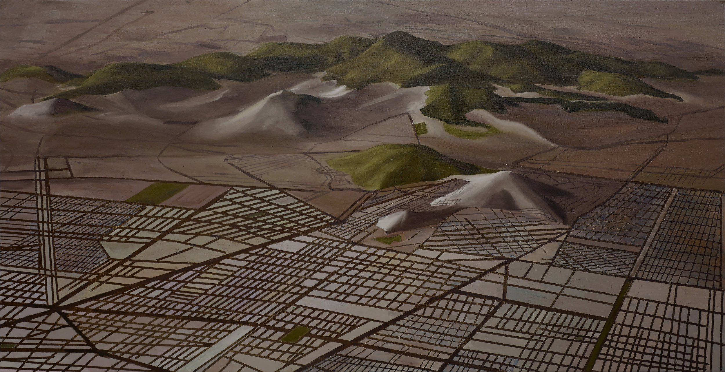
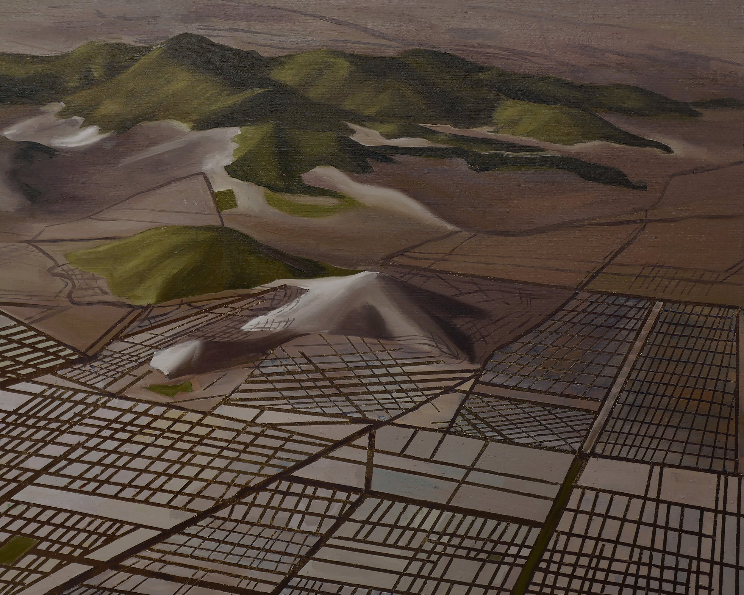
Every city begins with a plan that nobody lives in. The roads are drawn before the traffic arrives, the zoning assigned before the first resident considers a commute, the residential blocks shaded on a map before anyone has stood at the window and watched the light change across a room that does not yet exist. Tan Mu's Landscape (2021) is a painting of that moment before: a terrain that no foot has crossed, overlaid with a grid that no one has yet inhabited. Its source is not a photograph of an actual city seen from above but a virtual landscape generated inside a 3D modeling program, one that was subsequently dismantled, analyzed, and used as the basis for designing an urban residential complex. The terrain in the painting has never been walked on. The grid has never been built. Both exist only as data and as paint.
The painting, oil on linen, measures 20 x 40 inches (50.8 x 101.6 cm), a horizontal format that insists on the panoramic. Its proportions approximate a satellite view, or more precisely, the aspect ratio of a city-building game seen from above. At this scale, the canvas becomes a screen, and the screen becomes a window onto a place that is not a place. The ratio of width to height gives the composition its governing logic: the eye travels laterally, following the grid lines as they extend across the terrain, the same way a city planner's gaze moves across a master plan, or a gamer's cursor drifts across an empty map waiting to be filled.
Tan Mu has described how this visual language traces back to a trip to Mongolia, where the openness of the land and the rolling desert hills left a lasting impression. Those scenes, she says, later resurfaced through the city-building games she played as a child. In these games, players begin with an empty terrain and gradually introduce mountains, rivers, and infrastructure before constructing cities. Roads, residential zones, industrial areas, and transportation systems must all be carefully planned. One could zoom out to observe traffic patterns or zoom in to examine how disasters or congestion unfolded. This experience trained her to think about cities as systems rather than static images, and it shaped the way she understands the relationship between natural terrain and human intervention. The game was not a simulation of urban planning. It was urban planning, stripped of consequence and compressed into the logic of a play session. The terrain it offered was infinitely malleable, and the grid it imposed was the first act of civilization.
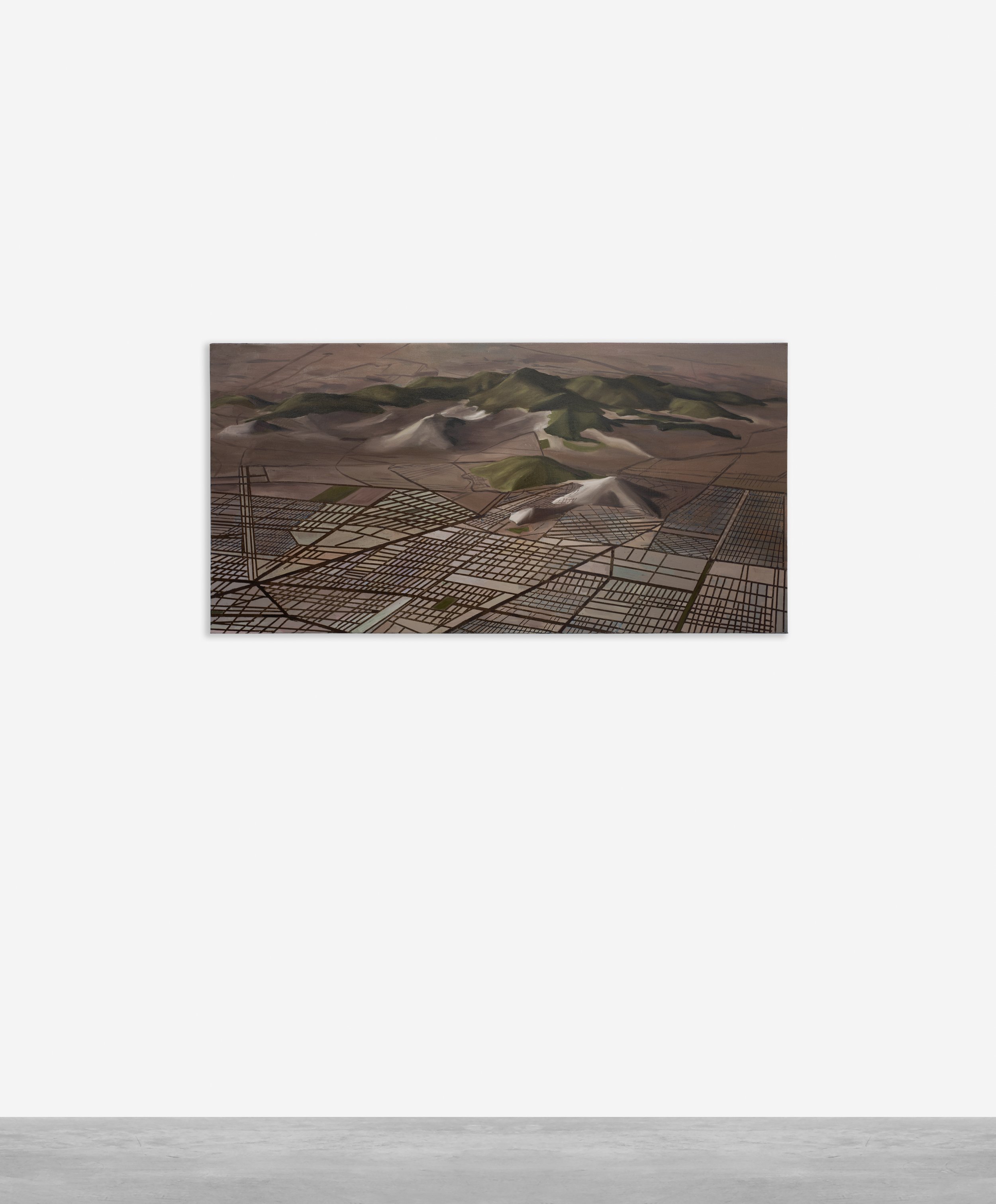
At arm's length, the surface of Landscape reveals its contradictions. The linen support shows through in places where the paint has been allowed to thin, its woven texture providing the faint grid of horizontal and vertical threads that underlies everything. This is not an accident. The linen's weave is itself a grid, a structural substrate that anticipates the compositional grid painted on top of it. Over this foundation, Tan Mu builds layers of oil paint, beginning with an underpainting that establishes the terrain: mountain forms, ridgelines, the soft undulations of land that might have existed before the grid was projected onto them. The colors of this underpainting, ochres and umbers, warm earth tones that suggest geological strata, occasionally bleed through the grid lines laid on top, as though the land is refusing to stay buried beneath the plan.
The grid itself is rendered with a deliberation that mimics the precision of digital drafting. Streets and zoning boundaries cross the canvas in straight lines and right angles, the geometry of urban planning superimposed on the organic curves of the terrain below. The contrast is not subtle. Where the underlying landscape rolls and shifts, the grid imposes rectilinear order, subdividing the painted surface into blocks and sectors that read as residential zones, industrial districts, transportation corridors. At three meters, the painting resolves into a readable aerial view: here is a city plan, here are neighborhoods, here is the logic of development. At thirty centimeters, the grid lines dissolve into individual brush marks, each one a discrete decision by the painter's hand, and the terrain beneath becomes a field of color relationships, accidental passages, and deliberate erasures. The transition between these two viewing distances enacts the painting's central tension: the grid is legible from a distance and handmade up close, just as a city plan is legible from a satellite and lived in from the street.
Tan Mu has described her process explicitly. "I begin by deconstructing this digital scene, analyzing its geometry, light, and spatial logic through digital methodologies. I then reconstruct it using oil painting, relying on color relationships, texture, and layering to create a sense of material presence." The word "reconstruct" is precise. She is not translating the digital image into paint in the manner of a photorealist rendering a screenshot. She is rebuilding the scene from scratch, using the digital model as a blueprint, making new decisions about color, edge, and surface that the model never contained. The result is a painting that occupies the territory between two orders of representation: the calculated, the designed, the virtual, and the embodied, the layered, the physical.
Charles Sheeler's American Landscape (1930) occupies a comparable position in the history of painting and industrial space, though the terms are reversed. Sheeler, commissioned by Ford to photograph and then paint the River Rouge plant in Dearborn, Michigan, produced a canvas in which the industrial complex fills the frame so completely that the plant itself becomes landscape. There are no trees, no sky that is not industrial, no horizon that is not a smokestack or a conveyor belt. The painting is 24 by 29 inches, a compact format that Sheeler used to compress the massive Ford facility into a composition so tightly organized that every element reads as both a functional component of the factory and a formal element of the painting. The railroad tracks in the foreground converge toward the middle ground, the smokestacks repeat in rhythmic verticals, and the water of the slip occupies the lower register like a mirror of the sky. Nothing is out of place. Nothing is accidental. The River Rouge plant, in Sheeler's rendering, is not depicted within a landscape; it has replaced the landscape.
The structural parallel to Landscape lies in this substitution. Sheeler takes an industrial complex and paints it as though it were a natural formation: the factory becomes the landscape, its smokestacks become trees, its rail lines become rivers. Tan Mu reverses the direction. She begins with terrain that has never been natural, a virtual landscape generated by algorithm, and paints it as though it were real, investing it with the warmth and texture and physical presence that only oil paint on linen can provide. Both paintings perform the same sleight of hand: they collapse the distinction between the manufactured and the given, between the designed and the found. Sheeler does it by making the factory look inevitable, as though it had always been there, a geological formation of steel and smoke. Tan Mu does it by making the virtual look inhabited, as though the grid had always been the shape of the land, as though the terrain had been waiting for the city to arrive.
The difference is one of direction. Sheeler's painting moves from the industrial toward the pastoral, borrowing the compositional strategies of landscape painting to dignify the factory. The Hudson River School, which established the visual vocabulary of the American landscape as a space of grandeur and possibility, is the invisible scaffolding behind Sheeler's composition. He gives the Ford plant the compositional dignity that Albert Bierstadt gave to Yosemite. Tan Mu moves in the opposite direction. She begins with the visual language of landscape, the contours of terrain, the warm colors of geological strata, and she overlays it with the visual language of planning, the grid, the zoning, the rectilinear order of a city that has not yet been built. The result is not a landscape that has been industrialized but a landscape that has been designed from the start. There is no "before" to the grid in this painting, no prior state of nature that the city interrupts. The terrain and the grid are coextensive, generated in the same program, existing in the same data structure.
The subject of Landscape is, in the artist's own words, a virtual landscape "created using a 3D modeling program" that was "dismantled, analyzed, and used to design an urban residential complex." The grid patterns "represent streets and zoning systems, forming a rigid framework that contrasts with the organic curves of mountains and terrain." This is not a painting of a real city seen from above. It is a painting of a digital model that was subsequently used to plan one. The distinction matters. When Tan Mu paints a submarine cable network or a cryostat, she is translating a real-world photograph into paint, adding layers of interpretation and material presence to something that already exists as a documentary image. When she paints Landscape, she is translating a model, a speculative object, a terrain that existed only as coordinates and polygons before she decided to give it a body in oil. The model was a plan for a future city. The painting is a plan for a plan, a representation of a representation, and in that doubling, something new enters the work: the knowledge that the landscape itself is a construction, that the terrain was designed to be designed upon, that the ground under the grid is no more natural than the grid itself.
The 3D modeling program that generated Tan Mu's source image belongs to a class of software that includes tools like CityEngine, SketchUp, and the urban planning modules of simulation games like SimCity and Cities: Skylines. These programs share a common logic: they begin with terrain, they allow the user to modify that terrain, and they provide tools for laying out roads, zoning districts, and infrastructure. The user starts from a god's eye perspective, looking down at an empty landscape, and gradually populates it with the structures of urban life. The god's eye view is not incidental to the experience; it is constitutive. You cannot plan a city from the street. You need the aerial perspective, the one that converts lived space into a pattern of blocks and corridors. Tan Mu has spoken about this perspective directly. "The god's eye view, whether encountered through gaming, aerial photography, or satellite imagery, offers a detached yet comprehensive way of observing the world. This perspective allows me to study urban structures, spatial organization, and human intervention without being grounded in a single physical position. From this elevated viewpoint, cities appear as patterns rather than lived spaces."
This detachment is both the power and the limit of the perspective. From above, a city is a system: roads become vectors, buildings become data points, neighborhoods become zones. The aerial view suppresses the experience of being inside the city, the way a street feels at ground level, the way light falls between buildings at different times of day, the way a neighborhood accumulates history through use. Tan Mu's painting restores some of what the aerial view takes away, not by abandoning the god's eye perspective but by painting through it, by adding layers of color and texture that the model never contained, by allowing the terrain to emerge through the grid, by giving the virtual landscape a body made of oil and linen. The underlying colors that "subtly emerge through the grid," as she describes, suggest depth and accumulation, the way cities themselves are built over time, layer upon layer. The painting does not simulate what the city would look like from the ground. It makes the god's eye view itself into a material experience, a view you can stand in front of and feel the weight of.
Robert Smithson's The Monuments of Passaic, New Jersey (1967) offers a different but structurally resonant treatment of the designed landscape. Smithson, traveling to his hometown on a Sunday afternoon, produced a series of photographs and a text that treated the construction sites, drainage pipes, and suburban developments of Passaic as monuments, artifacts of a civilization that had already begun to memorialize itself through its own infrastructure. The essay, published in Artforum, describes a landscape in which "the limits of the artificial" are indistinguishable from "the limits of the natural." Smithson's photographs show a world in which every surface has been shaped by engineering: the river channeled, the ground leveled, the horizon punctuated by cranes and concrete mixer trucks. The monuments of Passaic are not ruins of a past civilization but the ongoing construction of the present, the city building itself in real time and finding, in the process, that it has already become archaeology.
Smithson's concept of the "non-site" is relevant here. A non-site, in Smithson's practice, is a work made from materials taken from a specific location but displayed elsewhere, in a gallery, stripped of their original context. The gallery presentation, with its geometric containers and its distance from the original terrain, becomes a kind of map or diagram of the site, a representation that is more legible, more organized, and more alien than the site itself. Tan Mu's Landscape operates in an analogous space, though again with the terms reversed. Smithson takes materials from a real site and places them in a gallery, making the site into a non-site. Tan Mu takes a representation of a non-site, a virtual terrain that has no physical location, and gives it the material presence of a painting, making the non-site into something that can be seen, touched, and inhabited by the eye. The painting is not a non-site. It is the opposite: a site for something that never had one.
Smithson's Passaic photographs and Tan Mu's painted terrain share an awareness that the landscape has been fully colonized by design, that there is no "outside" to the planned environment. But where Smithson responds with irony, documenting the absurdity of a world that has already become its own monument, Tan Mu responds with care. She paints the grid as though it matters, as though the act of translating it into oil on linen could restore something that the digital model has abstracted away: the time of painting, the body of the painter, the texture of linen, the weight of pigment. The grid in Landscape is not a critique of urban planning. It is a record of what planning looks like when it is slowed down to the speed of a hand mixing colors on a palette.
Saul Appelbaum, writing about Tan Mu's practice in 2025, introduces the concept of "arbitration," drawn from his architectural thesis on noise and signal. For Appelbaum, Tan Mu's paintings and performances "unfold through a process of arbitration: deciding, judging, mediating between input and output." In the context of Landscape, this arbitration takes a specific form. The input is the 3D model, a set of coordinates and algorithms that generate terrain and impose a grid. The output is a painting, an object made of oil and linen, bearing the marks of a hand that has spent hours translating data into color. The arbitration occurs in the gap between these two orders. It is the moment when Tan Mu decides, for instance, to let the underpainting show through the grid, to let the terrain resist the plan, to let the warm earth tones bleed through the zoning lines as though the land were asserting itself against the design imposed upon it. This is not a random decision. It is a formal choice that enacts a philosophical position: that the terrain has a claim that the grid cannot fully overwrite, that the material has a say that the model cannot predict.
Appelbaum's framing also illuminates the role of the viewer. Standing in front of Landscape, the viewer is performing their own arbitration between the painting's two visual registers: the digital and the material, the planned and the painted, the grid and the terrain. At one distance, the work reads as an aerial view of a city plan, legible, orderly, functional. At another distance, it reads as a field of brush marks, layered, textured, human. The viewer must decide, from moment to moment, which register to attend to. This oscillation is not a defect. It is the painting's subject. Tan Mu has said that Landscape is "not only a response to the technological shaping of reality but also an exploration of the transformation between the virtual and the real, between rapid digital generation and handcrafted reproduction." The painting holds both registers simultaneously and refuses to resolve the tension between them. It does not argue that the material is more real than the virtual or that the hand is more authentic than the algorithm. It presents the algorithm as something that has already been painted over and the painting as something that has already been designed. The grid and the terrain coexist, and the viewer is the one who must navigate between them.
Tan Mu's own description of her process makes this arbitration explicit. "As I layer paint, underlying colors subtly emerge through the grid, suggesting depth and accumulation. This process mirrors the way cities themselves are built over time, layer upon layer." The analogy between painting and urban development is not decorative. It is structural. A city is built in layers: geological strata under infrastructure under streets under buildings under signage under light. A painting is built in layers: linen under gesso under underpainting under glazes under final marks. In both cases, earlier layers are never fully erased. They show through, they influence what comes after, they create the depth that a flat surface, whether urban or pictorial, would otherwise lack. The underpainting that bleeds through the grid in Landscape is the geological equivalent of the terrain asserting itself against the plan. It is the ground saying: I was here first.
The question that Landscape raises, and the question that Sheeler and Smithson each posed in their own century and their own medium, is whether the designed landscape can ever be anything other than a design. Sheeler's answer was to make the factory look like landscape, so natural that you could forget it was manufactured. Smithson's answer was to make the suburban development look like a ruin, so archaeological that you could forget it was ongoing. Tan Mu's answer is different. She makes the virtual look material, the planned look painted, the algorithmic look handmade, and then she lets the paint show the terrain underneath, as a reminder that even a terrain generated by a computer program was, at some point in its development, shaped by someone who decided where the mountains would go and how the rivers would flow. The virtual landscape in Landscape is not natural. It is designed to look natural. The grid on top of it is not organic. It is designed to organize. And the painting that contains them both is designed to make the viewer feel the distance between design and experience, between the plan and the place where the plan meets the ground, between the terrain that was never real and the painting that makes it feel as though it could be.
What remains after the virtual and the painted have been held in the same frame is not a synthesis but a tension that the painting refuses to resolve. The grid overlays the terrain. The terrain shows through the grid. The brush marks are deliberate, and they are also the evidence of a hand that spent hours making something that a program generated in seconds. The 20 x 40 inch format is both a canvas and a screen. The god's eye view is both a perspective and a position of power. Tan Mu's Landscape does not ask whether the virtual is real. It asks whether the real was ever anything other than designed.