The Sea That Became a Switchboard: Tan Mu's Signal: Submarine Network 08 and the Mediterranean Rewired
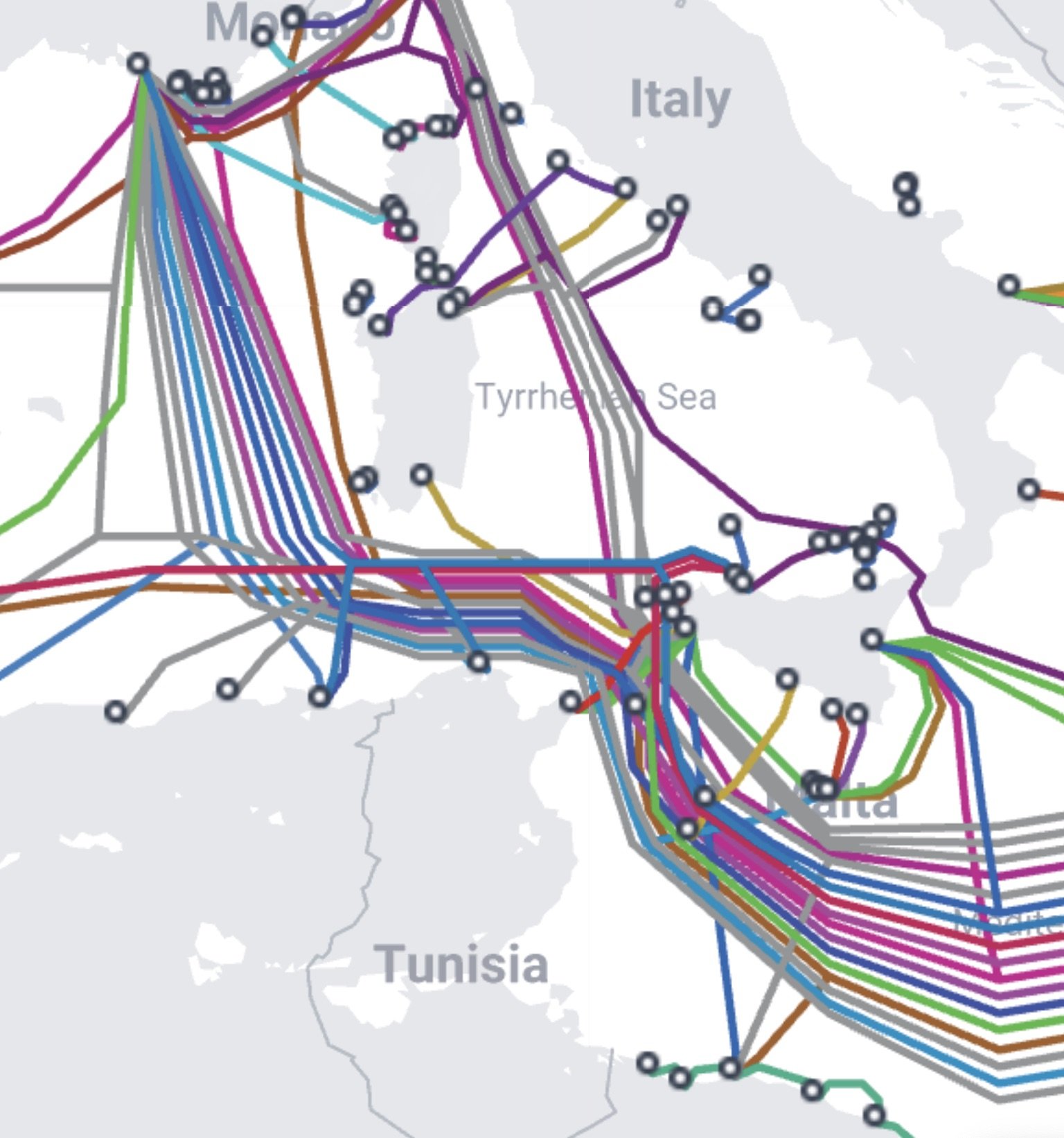
Three cables enter the Tyrrhenian Sea from the south, two from the east, one from the west. They converge at Sicily, the island that sits at the narrowest point of the Mediterranean, where the sea between Sicily and Tunisia measures roughly 130 kilometers and where the shortest path from Africa to Europe runs beneath the same water that Phoenician galleys crossed three thousand years ago. The cables are named SEA-ME-WE 4, UniTirreno, and BlueMed. They carry fiber optic signals between southern Europe, the Middle East, and Africa, routing data through a marine environment that has served as a trade corridor since the earliest recorded commerce. The Phoenicians carried purple dye and tin. The Romans carried grain and olive oil. The cables carry everything that the internet carries: financial transactions, medical records, video calls, satellite imagery, social media posts, military communications, weather data, and the accumulated weight of human expression as it moves through glass fibers thinner than a human hair at speeds that approach the speed of light. The Mediterranean has been rewired. The trade routes are still there. The cargo has changed.
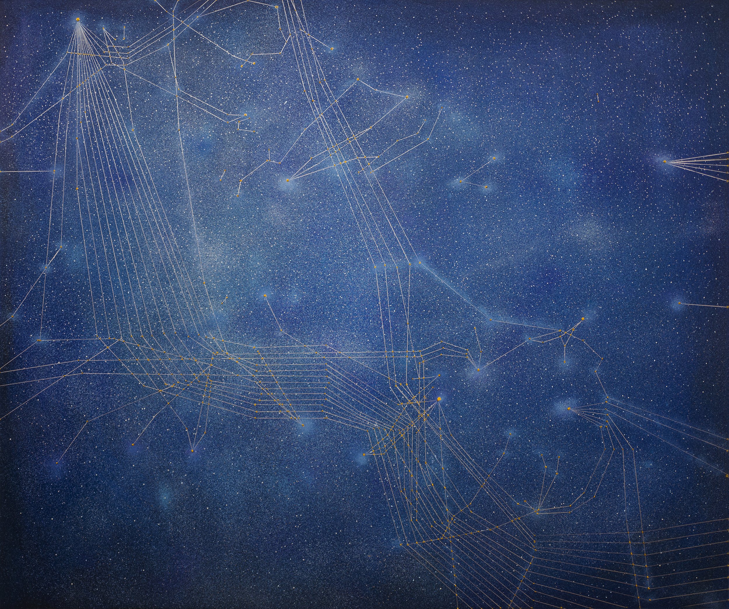
Signal: Submarine Network 08 (Italy) (2025) is oil and acrylic on linen, 152.5 x 183 cm (60 x 72 in), a horizontal rectangle that is wider than it is tall, a format that mirrors the expanse of sea and sky that the painting collapses into a single field. The dimensions are significant. The 152.5-centimeter height is roughly the height of a person standing with their arms raised, and the 183-centimeter width is roughly the span of a person's outstretched arms. The painting is the size of a body with its arms open, facing the sea. The horizontal format also mirrors the format of a nautical chart or a satellite image, the two kinds of documents that provide the source material for the painting's composition. Tan Mu works from maps of cable routes and from satellite photographs of the Mediterranean coastline, translating the technical data of cable systems into the visual language of painting, a process that requires her to decide, at every point, how much of the technical information to preserve and how much to transform into something that the viewer can experience without specialized knowledge.
The surface of the painting is divided into two fields that are not actually divided. The upper field reads as sky. The lower field reads as sea. Between them, there is no horizon line. The transition from one field to the other is a gradual shift in the density and distribution of marks, from sparser and more widely spaced dots in the upper portion to denser and more closely packed dots in the lower, with the zone of maximum density occurring at the approximate position where the horizon would be on a conventional seascape. This zone is the painting's equivalent of the waterline, the place where the surface of the ocean reflects the sky and the two become, for a moment, visually indistinguishable. Tan Mu describes this effect as coming directly from diving: "When you are underwater and look upward, the surface of the ocean reflects light in a way that resembles the night sky. In that moment, sea and sky collapse into a single plane." The painting reproduces this collapse by refusing to mark the boundary between the two fields, allowing the dots to function simultaneously as stars above and as cable nodes below, as celestial objects and as points of data, as things that can be seen with the naked eye from a beach at night and as things that can only be detected by the instruments that monitor the flow of information through fiber optic systems at the bottom of the sea.
The dots are the painting's structural unit. They range in size from pinpoints barely visible at arm's length to larger marks roughly the size of a pea, each one applied with a deliberate hand in a specific position on the surface. The smaller dots are rendered in acrylic, which dries quickly and allows Tan Mu to place them with precision. The larger dots, which correspond to the cable landing points and major branching nodes where multiple cables converge, are rendered in oil, mixed with the wax medium that gives the impasto in her Signal series its characteristic raised profile. These larger dots physically protrude from the surface, catching the gallery light in a way that the smaller dots do not, creating a tactile hierarchy that mirrors the functional hierarchy of the cable network: the major nodes where cables come ashore and branch into terrestrial networks are more physically present than the intermediate points that carry data between nodes without stopping. The color of the dots ranges from cool white and pale silver in the upper field, where the dots read as stars, to warmer white and pale gold in the lower field, where the dots read as data points or as the bioluminescence that Tan Mu would have seen during her dives off the coast near her childhood home. The shift in temperature from cool to warm is the painting's registration of the shift from sky to sea, from the cold light of stars to the warmer light of organic luminescence and fiber optic signal transmission.
The lines that connect the dots are thinner than any other mark in the painting. They are drawn in a pale gray or silver acrylic, and they trace the routes of the submarine cables across the surface with a fidelity that corresponds to the actual cable routes as they appear on the submarine cable maps maintained by TeleGeography and other industry sources. The SEA-ME-WE 4 cable enters from the southeast, running from the Suez Canal and the eastern Mediterranean toward Sicily. The UniTirreno cable runs along the western coast of Italy, connecting the Italian peninsula to Sicily and Sardinia. The BlueMed cable connects Sicily to the wider Mediterranean network, extending toward Greece, Turkey, and the eastern Mediterranean landing points. The lines cross and converge at specific points on the painting's surface, and where they converge, the dots are larger and more raised, marking the positions where the cables come ashore at landing stations in Catania, Palermo, and Mazara del Vallo, the Sicilian cities that serve as the terrestrial gateways for the data that arrives from beneath the sea. The lines are not decorative. They are diagrammatic. They correspond to real infrastructure. But they are also, as Tan Mu describes them, "contemporary constellations, mapping human movement, communication, and desire," lines drawn between points of light in a dark field, indistinguishable from the lines that ancient astronomers drew between stars to create the figures of Orion, Cygnus, and Cassiopeia.
The Hereford Mappa Mundi, created around 1300 and housed in Hereford Cathedral in England, is a circular map of the known world drawn on a single sheet of vellum measuring approximately 158 by 133 centimeters. Jerusalem sits at the center. The Mediterranean runs from the bottom center of the circle toward the middle, a narrow vertical channel flanked by Europe on the left and Africa on the right, with Sicily visible as a triangular island at the narrowest point between the two continents. The map is not a tool for navigation. It is a theological document. The arrangement of the landmasses expresses a cosmology in which the sacred geography of the Bible determines the position of every feature. Paradise is at the top, the Far East. The Pillars of Hercules, marking the western entrance to the Mediterranean, are at the bottom. The known world is contained within the circle, and everything outside the circle is either unknown or theological. The map does not show the ocean floor. It does not show cables. It does not show data. It shows the world as a theological system, organized around a center that is also a meaning, a point where geography and doctrine converge.
The structural parallel with Signal: Submarine Network 08 is not one of appearance. The Hereford map is colorful, crowded, and figurative. Tan Mu's painting is monochromatic, spare, and abstract. The parallel is one of function. Both works are maps of a world organized around a center that is also a meaning. In the Hereford map, the center is Jerusalem, the site of the crucifixion, the point where the divine enters the human. In Tan Mu's painting, the center is Sicily, the point where the cables converge, the site where the data from Africa, the Middle East, and southern Europe enters the European terrestrial network and is distributed to the rest of the continent. Both centers are switching points. Both centers are where routes converge and where cargo, whether spiritual or digital, is transferred from one system to another. The Mediterranean in the Hereford map is a corridor between the holy places of the East and the Christian kingdoms of the West. The Mediterranean in Tan Mu's painting is a corridor between the data centers of the Middle East and the server farms of Europe. The Phoenicians carried purple dye. The cables carry packets. The sea is the same sea. The narrow passage between Sicily and Tunisia is the same passage. The convergence point is the same convergence point. The only thing that has changed is what flows through it.
The Mediterranean has always been a sea of convergences. The name itself means the sea in the middle of the earth, the sea between the lands, and its geography has determined its function. Surrounded by three continents, connected to the Atlantic only through the narrow Strait of Gibraltar, connected to the Black Sea only through the Dardanelles and the Bosporus, the Mediterranean is a closed system that forces every trader, every migrant, every fleet, and every cable that wants to move between Africa, Europe, and Asia to pass through a limited number of choke points. Sicily sits at one of them. The Sicilian Channel, the stretch of water between the island and the Tunisian coast, is roughly 130 kilometers wide and averages about 300 meters in depth, making it shallow enough for cable installation and narrow enough to minimize the cost of the cable run. These geographic facts determined where the Phoenicians built their trading posts, where the Romans built their grain ports, where the Allied forces landed in 1943, and where the fiber optic cables now land. The geography has not changed. The infrastructure has changed. The painting records the moment when the infrastructure changed from the kind that carries grain in wooden hulls to the kind that carries light in glass fibers.
The cables that converge at Sicily carry approximately 90 percent of the data that travels between Africa, the Middle East, and Europe. The remaining 10 percent travels by satellite. The ratio has held since the early 2000s, when the first submarine fiber optic cables replaced the copper coaxial cables and satellite links that had previously carried intercontinental traffic. The advantage of fiber optic cable is bandwidth. A single fiber, a strand of glass roughly 250 micrometers in diameter, can carry multiple terabits of data per second. A cable bundle typically contains between 12 and 24 fiber pairs, each one capable of carrying independent streams of data in both directions. The total capacity of the SEA-ME-WE 4 cable, which entered service in 2005, is approximately 4 terabits per second. The total capacity of the newer SEA-ME-WE 5 and SEA-ME-WE 6 cables, which run parallel routes, is several orders of magnitude larger. The cables land at designated stations, typically in industrial buildings near the shoreline, where the undersea fiber is connected to terrestrial fiber networks that route the data to its destination. The landing station at Mazara del Vallo, on the western tip of Sicily, is one of the most important switching points in the global internet. Data that travels from Cairo to London, from Dubai to Frankfurt, from Nairobi to Paris passes through this station. The station is not visible in the painting. The painting shows the sea and the sky and the dots and the lines. The station is beneath the surface, beneath the dots, beneath the paint, a point of convergence that the painting marks with a raised node of wax-heavy impasto but does not depict, because the station is not what the painting is about. The painting is about the convergence itself, the fact that routes come together at specific points on the earth's surface for reasons that are determined by the shape of the seabed and the distance between coastlines, and that these reasons have not changed since the Phoenicians first calculated the shortest rowing distance between Carthage and Sicily.
Vija Celmins's Untitled (Night Sky) (2003) is a painting of the night sky that is also a painting of the surface of a painting. The work is oil on wood, 20 by 24 inches, and it consists of an apparently random distribution of small white and pale yellow marks against a dark ground. The marks represent stars, and the dark ground represents the sky. But the relationship between the marks and the sky is not one of depiction. Celmins works from photographs of the night sky, not from direct observation, and she makes this distinction explicit in her process: she transfers the photographic image to the painting surface by hand, dot by dot, mark by mark, producing a painting that is not a representation of the night sky but a representation of a photograph of the night sky, which is itself a mechanical record of the light that reached the camera lens at a specific moment in time. The painting is a representation of a representation of a representation: the sky, the photograph, the painting. Each step introduces a specific kind of mediation, and the final result is a surface that looks like a night sky but is actually a painting of a photograph of a night sky, and the difference between what it looks like and what it is constitutes the work's conceptual content.
The parallel with Signal: Submarine Network 08 is structural. Both paintings present a field of dots against a dark ground. Both paintings derive their dot patterns from a source that is not visible in the final work: Celmins from a photograph, Tan Mu from a submarine cable map. Both paintings require the viewer to recognize that the dots are not abstract marks but representations of specific things: stars in one case, cable nodes in the other. Both paintings refuse to identify which dots are which, leaving the viewer to determine whether a particular mark is a star, a data point, a pixel, or a particle of white noise, and the answer depends on which layer of the painting's content the viewer chooses to attend to. But the differences are as instructive as the similarities. Celmins's dots are uniform in size and tone, producing a field that is consistent and evenly distributed, a faithful transcription of the photographic source. Tan Mu's dots vary in size, color temperature, and surface profile, producing a field that is hierarchical and directional, with larger and more raised dots marking the positions of the cable landing stations and smaller and flatter dots marking the intermediate nodes. Celmins's painting is a field without a center. Tan Mu's painting is a field organized around a center: Sicily, the convergence point, the place where the routes come together and the data switches from one system to another. Celmins's sky is infinite and isotropic. Tan Mu's sky is finite and directed, a network with specific topology and specific points of maximum density that correspond to specific places on the surface of the earth. The difference is the difference between a cosmos and a network, between a system that extends in all directions without preference and a system that routes information along specific paths toward specific destinations. Celmins paints the universe. Tan Mu paints the internet. The dots look the same. The systems they describe are different.
Yiren Shen, writing about the 2025 BEK Forum exhibition, describes Tan Mu's Signal paintings as "reconfiguring the globe as a network of luminous nodes that simultaneously map physical infrastructure and collective memory." The phrase captures the dual function of the dots in Signal: Submarine Network 08. Each dot is a physical node, a landing station or a branching point where cables come ashore. Each dot is also a trace of memory, a mark that records the passage of information through a specific point on the earth's surface, a point that has been a crossing for as long as humans have moved goods and ideas across the Mediterranean. The dots do not choose between these functions. They hold both simultaneously, and the viewer who recognizes them as cable landing stations also recognizes them as the heirs of the Phoenician trading posts and the Roman grain ports that occupied the same positions on the same coastline for the same geographic reasons. The convergence at Sicily is not an accident of engineering. It is a consequence of geography. The shortest cable route from Africa to Europe passes through the Sicilian Channel because the shortest sailing route from Carthage to Rome also passed through the Sicilian Channel, and the shortest rowing route from Crete to Sicily passed through the same channel before that, and the sea has not moved, and the island has not moved, and the distance between them has not changed.
Tan Mu's personal connection to the ocean is the connective tissue of the entire Signal series. Her mother was a professional windsurfer. Her grandfather was a marine engineer who worked on port design and land reclamation. She grew up by the sea, sailing, observing the movement of wind and water, studying the marine maps and technical drawings that her grandfather brought home from his projects. She is a freediver who has experienced, in her own body, the moment when the ocean surface seen from below resembles the night sky. The Signal series grew from this personal history, beginning with the 2022 painting Eruption, which responded to the volcanic eruption in Tonga that damaged submarine cables and cut the country off from global communication. The experience made visible the infrastructure that had been invisible, and the series expanded from that moment, mapping cable networks region by region, ocean by ocean, until it reached the Mediterranean, the sea that has been a trade corridor since before history began. Signal: Submarine Network 08 is the eighth painting in the series and the one that covers the oldest trade routes in the Western world. The cables that pass through the Sicilian Channel are the latest cargo on the oldest route. The painting records the latest cargo. It does not forget the oldest route.
The reference to The Classic of Mountains and Seas, the ancient Chinese text that maps the mythical and the unknown, is Tan Mu's way of placing the Signal series within a tradition that is older than Western cartography. The Shan Hai Jing, as it is known in Chinese, is a compendium of geography, mythology, and natural history compiled over several centuries, beginning in the Warring States period and reaching its current form during the Han Dynasty. It describes mountains, rivers, seas, and the creatures that inhabit them, mixing empirical observation with legendary material in a way that makes no distinction between what can be verified and what can only be imagined. The text does not separate geography from mythology. It treats them as the same kind of knowledge, two ways of describing a world that contains both the visible and the invisible, the mapped and the unmapped, the known coast and the unknown ocean beyond the edge of the chart. Tan Mu describes the Signal series as inspired by this tradition: "Like ancient chroniclers who charted mystical landscapes, Signal transforms the unseen digital networks of our era into a contemporary narrative." The submarine cables are the mythical creatures of the contemporary ocean. They are invisible. They are vast. They carry the forces that sustain civilization. They cannot be seen from the surface. They can only be mapped, and the map, like the Shan Hai Jing, mixes empirical observation with imaginative reconstruction, producing a document that is both a technical record and a work of speculative geography.
The Mediterranean was a sea before it was a switchboard. The Phoenicians knew it as a corridor. The Romans knew it as a lake. The medieval cartographers knew it as the center of the world. The cable engineers know it as a shallow channel with good landing conditions and short cable runs. All of these knowledges are correct. All of them describe the same sea. The difference is the kind of traffic that passes through it, and the kind of knowledge that the traffic produces. The Phoenicians produced knowledge of ports and tides. The Romans produced knowledge of grain yields and fleet movements. The cartographers produced knowledge of theological geography. The cable engineers produce knowledge of bandwidth, latency, and signal attenuation. Each kind of knowledge generates its own maps, and each map shows the same sea organized around the same convergence points, because the sea has not moved and the island has not moved and the distance between Sicily and Tunisia has not changed. The painting holds all of these maps simultaneously. It is a nautical chart. It is a star chart. It is a cable map. It is a theological document. It is a work of speculative geography. The dots are stars and nodes and trading posts and grain ports and landing stations and mythical creatures and particles of white noise. The lines are cable routes and trade routes and constellation lines and meridian channels. The dark field is the sea and the sky and the deep space between stars and the inside of a server and the bottom of the Mediterranean and the surface of a painting that is also the surface of the ocean seen from below by a diver who has been underwater long enough to forget which direction is up.