The Grid That Preceded the City: Tan Mu's Landscape and the Terrain That Was Drawn Before It Was Built
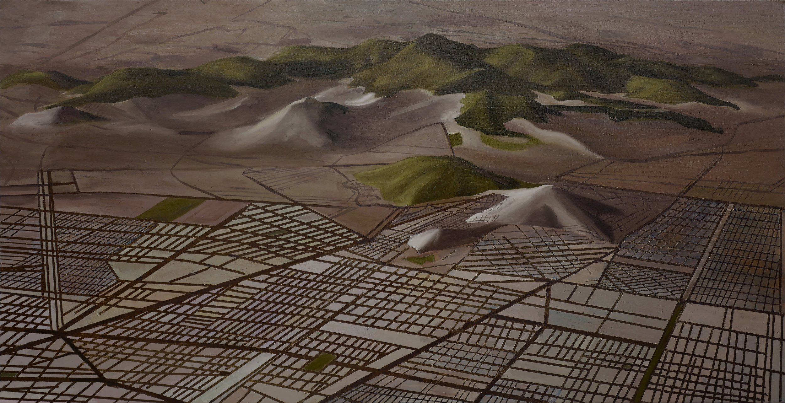
Li Yizhuo, writing on Tan Mu's practice in 2025, observed that her paintings "conjure up a kind of vitality and depth of their own" by refusing to diagnose the modern spectacle from a distance, choosing instead to inhabit the systems they depict. The observation is precise, and it is especially precise about Landscape, a painting that does not depict a landscape in the way that landscape paintings have traditionally depicted landscapes. The painting depicts a landscape that does not exist. The terrain, the mountains, the grid of streets and zones that overlays the terrain, the urban plan that the grid represents: all of these were generated inside a 3D modeling program, a software environment in which the user begins with an empty coordinate space and introduces geometry by clicking and dragging, building mountains from polygon meshes, defining streets as vectors, assigning materials to surfaces, and rendering the result with simulated light. The landscape in the painting has no location. It has no weather. It has no residents. It has never been walked on or built on or photographed from a helicopter. It exists only as a set of instructions that a computer has executed to produce an image, and Tan Mu has taken that image, dismantled it, analyzed its geometry and spatial logic, and reconstructed it in oil paint on linen, a process that she describes as creating "a dialogue between the calculated logic of digital tools and the emotional warmth of painting by hand." The dialogue is the painting's subject, and it is a dialogue that no traditional landscape painting could have, because no traditional landscape painting was ever derived from a file that could be deleted with a keystroke.
Oil on linen, 20 x 40 inches, 50.8 x 101.6 cm. The format is panoramic, twice as wide as it is tall, the proportions of a cinema screen or a satellite image, a format that insists on breadth rather than depth, on the horizontal spread of terrain rather than the vertical stack of foreground, middle ground, and background that traditional landscape painting inherited from the window of the Renaissance picture plane. The canvas reads as an aerial view, a perspective from which the terrain can be seen as a system rather than a scene, the way a satellite sees the earth or a drone footage camera sees a construction site or a city planner sees a map. The colors are muted and close in value: ochres, pale greens, dusty blues, and the grays of unpaved roads and unfinished foundations. The mountains in the background are rendered in soft, atmospheric tones that suggest distance and geological age, the kind of colors that the earth produces over millions of years of erosion and sedimentation. The grid that overlays the terrain is rendered in sharper, more saturated tones: the straight lines of streets and zoning boundaries, the rigid geometry of blocks and lots, the rectilinear order that urban planning imposes on the organic curves of natural topography. The contrast between the soft geology and the hard geometry is the painting's visual engine, and it is also its argument: the grid comes after the terrain but is painted on top of it, the way a city is built on top of the land, the way a plan is laid over a site, the way a digital model is generated inside a coordinate system that was designed to accommodate any geometry the user chooses to introduce.
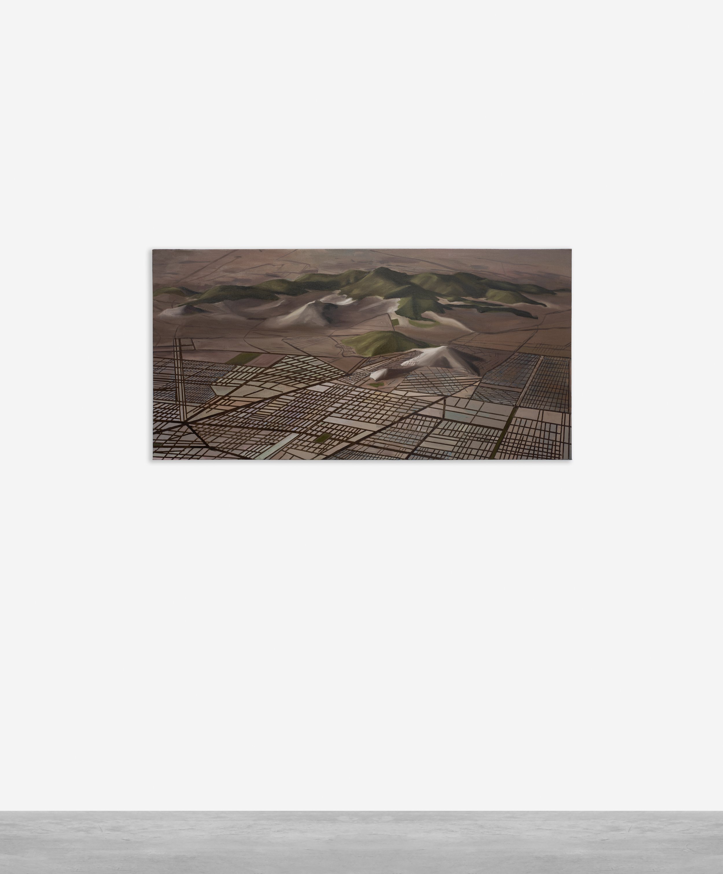
At close range, the surface reveals the tension between the two systems of mark-making that the painting contains. The mountains and terrain passages are built from layers of semi-transparent pigment that allows underlying colors to show through, producing the effect of geological depth, of strata visible through strata, of the kind of accumulated time that the earth records in its own surface. The grid lines, by contrast, are painted in a single, confident stroke, straight-edged, opaque, the kind of mark that a brush makes when it is following a predetermined path rather than searching for one. The grid does not adapt to the terrain. It overrides it. The streets cut across slopes without curving, the zoning blocks ignore the contours of the hills, and the intersections occur at regular intervals that have nothing to do with the irregular spacing of the mountain ridges. The grid is the plan, and the plan does not negotiate with the land. It sits on top of the land the way a screen sits on top of a window, defining what can be seen and how it can be organized, and the painting makes this relationship visible by painting the plan as a separate layer, a system of lines that floats on the surface of the terrain like a map pinned to a wall, or like the wireframe overlay that a 3D modeling program displays when the user switches from rendered view to wireframe view, revealing the geometry that underlies the image.
Charles Sheeler painted American Landscape in 1930, and the painting remains the most sustained meditation on the relationship between industrial geometry and natural terrain in twentieth-century American art. The canvas, roughly three feet wide, presents a view across a body of water toward a industrial complex: a power plant, a railroad, a conveyor system, and the smokestacks that mark the site of the Ford Motor Company's River Rouge plant in Dearborn, Michigan. The water in the foreground is calm and reflective. The sky is a high, pale blue. The industrial complex occupies the middle distance with a geometric precision that eliminates every trace of irregularity: the buildings are rectangles, the smokestacks are cylinders, the railroad tracks are parallel lines that recede to a vanishing point, and the conveyors are horizontal bands that span the width of the composition like the scan lines on a video monitor. Sheeler called his method "precisionism," and the term describes both a style and a conviction: the conviction that industrial architecture possessed an aesthetic integrity that was equal to the aesthetic integrity of any natural landscape, and that the painter's task was to reveal this integrity by rendering the industrial form with the same clarity and composure that a landscape painter brings to a mountain or a lake.
Sheeler's industrial landscape is not a critique of industrialization. It is a portrait of a condition in which the industrial and the natural have become indistinguishable, or rather, a condition in which the industrial has replaced the natural as the content of the landscape, and the landscape tradition, which has always organized the visible world into a composition of receding planes and atmospheric effects, now applies its organizing principles to smokestacks and conveyor belts instead of trees and rivers. Tan Mu's Landscape extends this condition into the digital era. Where Sheeler painted an industrial complex that had already been built, Tan Mu paints an urban plan that has not yet been built, a set of geometric instructions that exist only in a computer file and that will, if the plan is executed, produce a city that looks the way the file says it should look. The grid in Tan Mu's painting is the grid that Sheeler's conveyors and railroads implied: a system of rectilinear organization that converts the irregular surface of the earth into a series of buildable lots, each one a rectangle, each one defined by its relationship to the streets that border it, each one a unit in a system that produces order at the expense of the terrain's original geometry. Sheeler painted the result of this conversion. Tan Mu paints the conversion itself, the moment when the grid is drawn over the terrain and the terrain becomes a site, the moment when the coordinate system of the 3D model replaces the coordinate system of the earth.
The 3D modeling program that generated the source image for Landscape is a tool for designing urban environments. The user begins with an empty terrain, which can be generated algorithmically from elevation data or sculpted by hand, and then introduces infrastructure: roads, residential zones, commercial districts, industrial areas, parks, and transportation systems. The program calculates the relationships between these elements, ensuring that roads connect, that zones are properly sized, that the overall plan is internally consistent. The result is a virtual city that exists only in the computer's memory and can be viewed from any angle, at any scale, with any lighting condition, before a single foundation is dug or a single beam is raised. Tan Mu describes this process as one in which "technology predefines and constructs the blueprint for urban development," and the phrase is exact. The 3D model is not a representation of a city that will be built. It is the blueprint from which the city will be built, and the blueprint precedes the construction in the same way that the grid precedes the building, in the same way that the coordinate system precedes the geometry that is placed within it, in the same way that the plan precedes the execution.
The relationship between the virtual terrain and the physical painting is the relationship that the painting makes visible. The terrain in the 3D model is a set of polygons defined by vertices and faces, each one a mathematical object that the computer renders as a visual surface by applying textures, lighting, and perspective. Tan Mu takes this visual surface and reproduces it in oil paint, layer by layer, color by color, line by line, in a process that she describes as "mirroring the way cities themselves are built over time, layer upon layer." The analogy between painting and building is not casual. It is structural. The painting is built the way the city is built: from the ground up, in layers, each one dependent on the one below it, each one adding detail and complexity to the structure that the previous layer established. The terrain goes down first, like a foundation. The grid goes down second, like streets. The zones and blocks go down third, like buildings. And the final layer, the layer that completes the image, is the paint itself, the physical substance that converts the virtual model into a material object, the way concrete converts a blueprint into a building.
Piet Mondrian's Broadway Boogie Woogie (1942-43) is a painting of a city rendered as a grid, and it is the last painting Mondrian completed before his death in 1944. The canvas is organized by a network of vertical and horizontal lines that subdivide the surface into rectangles of varying size, and the rectangles are filled with small blocks of red, blue, and yellow that pulse against the white ground like the traffic lights and neon signs of the Manhattan streets that Mondrian could see from his studio on East 59th Street. The painting is not a representation of Broadway. It is a translation of the experience of Broadway into the visual language of the grid, the same language that Mondrian had been developing since 1917, when he began restricting his canvases to horizontal and vertical lines and the three primary colors, a restriction that he understood not as a limitation but as a clarification, a stripping away of everything that was not essential to the structure of the image.
Mondrian's grid is not the grid of urban planning. It is the grid of painting, a structure that organizes the surface into a system of relationships that the eye can read the way the mind reads a sentence, from left to right, top to bottom, parsing the relationships between the parts and constructing a meaning from the whole. But the grid of painting and the grid of urban planning share a deep structural property: both impose a rectilinear order on a surface that has no inherent order, and both produce a legibility that the surface did not possess before the grid was applied. Tan Mu's Landscape holds both grids in suspension. The grid of the urban plan, which overlays the terrain and converts it into a system of buildable lots, is visible as a set of painted lines that cut across the painted mountains with a regularity that no natural formation could produce. The grid of the painting, which organizes the canvas into a system of compositional relationships, is visible in the panoramic format, the horizontal spread, the aerial perspective, and the layered construction that builds the image from terrain to plan to paint. The two grids are not the same, but they produce the same effect: they make the terrain legible, they convert the organic into the systematic, they replace the irregular with the regular, and they produce a surface that can be read, interpreted, and acted upon, whether the reader is a city planner studying a zoning map or a viewer studying a painting. Li Yizhuo's observation about Tan Mu's refusal to diagnose from a distance is especially relevant here. The painting does not judge the grid. It does not argue that the grid destroys the terrain or that the grid is necessary for the terrain to become habitable. It holds both conditions in view simultaneously, the terrain without the grid and the terrain with the grid, the land before the city and the land after the city, and it allows the viewer to see the transformation as a process rather than a verdict, a conversion that is still underway, a blueprint that has not yet been built, a file that has not yet been deleted.
The panoramic format is the final term in the painting's argument, and it is the term that connects the virtual landscape to the tradition of landscape painting most directly. The panorama, from the Greek words for "all" and "view," was invented in the late eighteenth century as a form of entertainment: a large circular painting that surrounded the viewer with a continuous image, creating the illusion of being present in the scene. The panorama was the first medium to make the landscape immersive, to replace the framed window of the Renaissance picture plane with a surrounding field that the viewer could not escape. The 3D modeling program produces the same effect by a different means: instead of surrounding the viewer with a painted cylinder, it generates a virtual environment that the viewer can navigate, rotating the view, zooming in and out, moving through the terrain as if walking or flying. Tan Mu's painting takes the navigable virtual environment and converts it back into a framed view, a window rather than a surround, a composition rather than a simulation. The conversion is not a retreat from the immersive promise of the virtual. It is a decision to hold the virtual at a distance, to frame it, to make it visible as an image rather than an experience, and this decision is the decision that painting has always made, the decision to stop time, to fix the view, to convert the flow of experience into the stillness of the surface, the way a blueprint converts the process of building into the permanence of a plan, the way a grid converts the irregularity of the terrain into the legibility of the map, the way a painting converts a file that could be deleted into an object that cannot, because the paint has dried and the linen is stretched and the grid has been committed to a surface that will last longer than the software that generated the terrain it depicts, longer than the hardware that ran the software, longer than the city that the plan proposes, longer than any building that will be built on the site the grid defines, a terrain that was drawn before it was built, a landscape that was modeled before it was painted, a grid that was computed before it was drawn, and a painting that will be here when the model is obsolete and the city is built and the terrain, under all the layers of concrete and asphalt and zoning, is still there, doing what terrain does, eroding and sedimenting and accumulating the time that the grid tried to organize into blocks and lots and streets, the time that the painting has caught and held in layers of ochre and green and gray, the time that the landscape, virtual or physical, painted or built, has always contained and that the grid, no matter how precisely it is drawn, can never fully contain.